You are here: Home > Network List > CI - Caltech Regional Seismic Network Stations List
> Station MPM Manuel Prospect Mine, California, USA > Earthquake Result Viewer
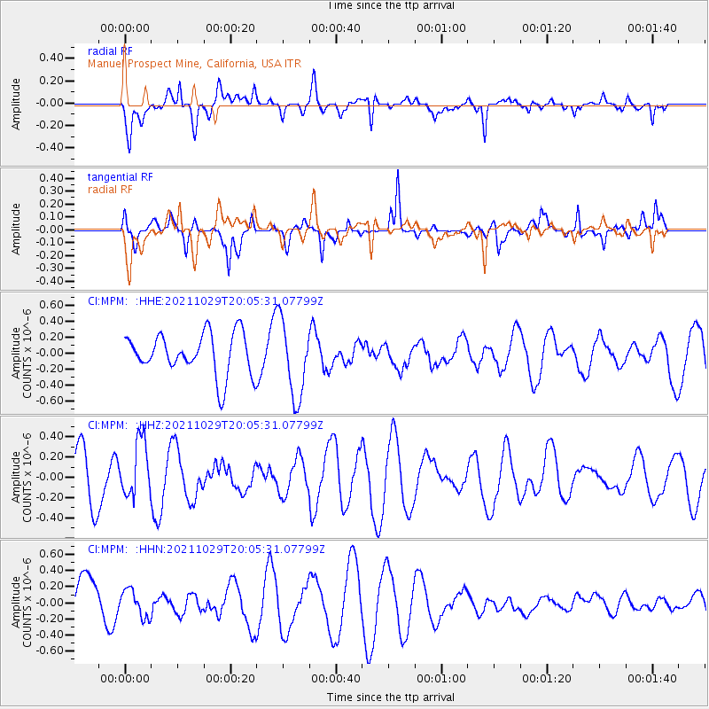
MPM Manuel Prospect Mine, California, USA - Earthquake Result Viewer
*The percent match for this event was below the threshold and hence no stack was calculated.
| Earthquake location: |
Near Coast Of Peru |
| Earthquake latitude/longitude: |
-15.1/-74.0 |
| Earthquake time(UTC): |
2021/10/29 (302) 19:55:26 GMT |
| Earthquake Depth: |
73 km |
| Earthquake Magnitude: |
5.2 Mww |
| Earthquake Catalog/Contributor: |
NEIC PDE/us |
|
| Network: |
CI Caltech Regional Seismic Network |
| Station: |
MPM Manuel Prospect Mine, California, USA |
| Lat/Lon: |
36.06 N/117.49 W |
| Elevation: |
185 m |
|
| Distance: |
65.4 deg |
| Az: |
322.171 deg |
| Baz: |
133.018 deg |
| Ray Param: |
$rayparam |
*The percent match for this event was below the threshold and hence was not used in the summary stack. |
|
| Radial Match: |
54.559006 % |
| Radial Bump: |
400 |
| Transverse Match: |
51.09191 % |
| Transverse Bump: |
320 |
| SOD ConfigId: |
26497111 |
| Insert Time: |
2021-11-12 20:02:43.947 +0000 |
| GWidth: |
2.5 |
| Max Bumps: |
400 |
| Tol: |
0.001 |
|
Signal To Noise
| Channel | StoN | STA | LTA |
| CI:MPM: :HHZ:20211029T20:05:31.07799Z | 0.979599 | 2.8035063E-7 | 2.861892E-7 |
| CI:MPM: :HHN:20211029T20:05:31.07799Z | 0.9693423 | 1.6986738E-7 | 1.7523983E-7 |
| CI:MPM: :HHE:20211029T20:05:31.07799Z | 1.8780533 | 4.7960384E-7 | 2.5537287E-7 |
| Arrivals |
| Ps | |
| PpPs | |
| PsPs/PpSs | |


