You are here: Home > Network List > CI - Caltech Regional Seismic Network Stations List
> Station NEE2 Needles Airport > Earthquake Result Viewer
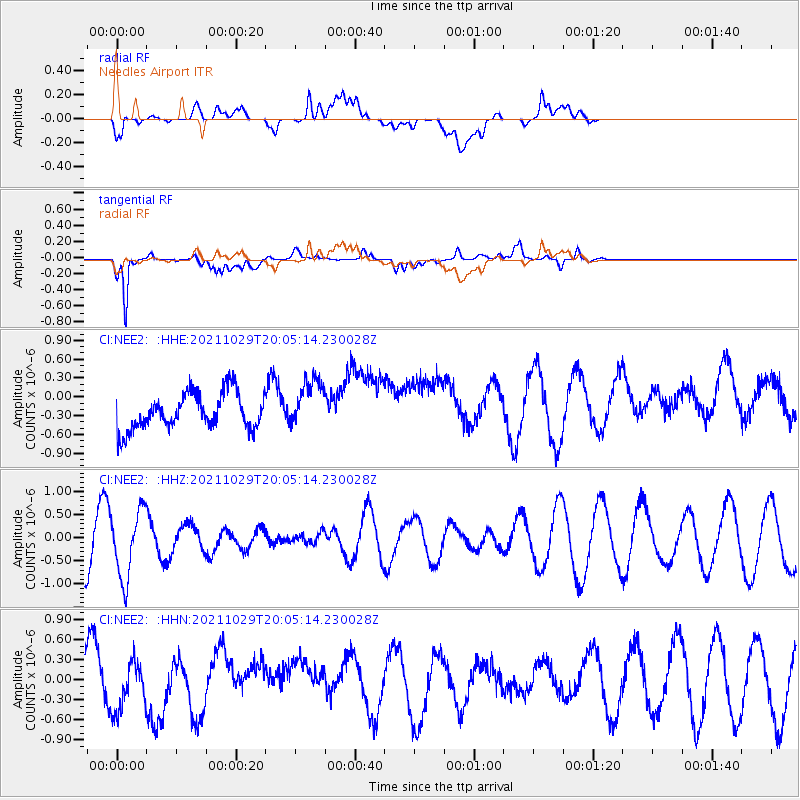
NEE2 Needles Airport - Earthquake Result Viewer
*The percent match for this event was below the threshold and hence no stack was calculated.
| Earthquake location: |
Near Coast Of Peru |
| Earthquake latitude/longitude: |
-15.1/-74.0 |
| Earthquake time(UTC): |
2021/10/29 (302) 19:55:26 GMT |
| Earthquake Depth: |
73 km |
| Earthquake Magnitude: |
5.2 Mww |
| Earthquake Catalog/Contributor: |
NEIC PDE/us |
|
| Network: |
CI Caltech Regional Seismic Network |
| Station: |
NEE2 Needles Airport |
| Lat/Lon: |
34.77 N/114.62 W |
| Elevation: |
271 m |
|
| Distance: |
62.8 deg |
| Az: |
322.953 deg |
| Baz: |
135.015 deg |
| Ray Param: |
$rayparam |
*The percent match for this event was below the threshold and hence was not used in the summary stack. |
|
| Radial Match: |
55.134155 % |
| Radial Bump: |
400 |
| Transverse Match: |
81.22633 % |
| Transverse Bump: |
400 |
| SOD ConfigId: |
26497111 |
| Insert Time: |
2021-11-12 20:02:47.740 +0000 |
| GWidth: |
2.5 |
| Max Bumps: |
400 |
| Tol: |
0.001 |
|
Signal To Noise
| Channel | StoN | STA | LTA |
| CI:NEE2: :HHZ:20211029T20:05:14.230028Z | 1.5404145 | 7.276409E-7 | 4.7236696E-7 |
| CI:NEE2: :HHN:20211029T20:05:14.230028Z | 1.0487103 | 3.5985585E-7 | 3.4314132E-7 |
| CI:NEE2: :HHE:20211029T20:05:14.230028Z | 1.3753916 | 3.902865E-7 | 2.837639E-7 |
| Arrivals |
| Ps | |
| PpPs | |
| PsPs/PpSs | |


