You are here: Home > Network List > UU - University of Utah Regional Network Stations List
> Station FSB1 FORGE surface borehole 1, UT, USA > Earthquake Result Viewer
FSB1 FORGE surface borehole 1, UT, USA - Earthquake Result Viewer
| Earthquake location: |
Near Coast Of Peru |
| Earthquake latitude/longitude: |
-15.1/-74.0 |
| Earthquake time(UTC): |
2021/10/29 (302) 19:55:26 GMT |
| Earthquake Depth: |
73 km |
| Earthquake Magnitude: |
5.2 Mww |
| Earthquake Catalog/Contributor: |
NEIC PDE/us |
|
| Network: |
UU University of Utah Regional Network |
| Station: |
FSB1 FORGE surface borehole 1, UT, USA |
| Lat/Lon: |
38.48 N/112.89 W |
| Elevation: |
1697 m |
|
| Distance: |
64.5 deg |
| Az: |
326.93 deg |
| Baz: |
137.806 deg |
| Ray Param: |
0.058680855 |
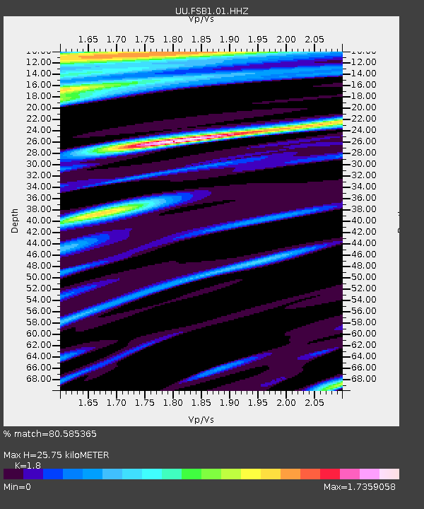
| Estimated Moho Depth: |
25.75 km |
| Estimated Crust Vp/Vs: |
1.80 |
| Assumed Crust Vp: |
6.276 km/s |
| Estimated Crust Vs: |
3.487 km/s |
| Estimated Crust Poisson's Ratio: |
0.28 |
|
| Radial Match: |
80.585365 % |
| Radial Bump: |
400 |
| Transverse Match: |
64.94247 % |
| Transverse Bump: |
400 |
| SOD ConfigId: |
26497111 |
| Insert Time: |
2021-11-12 20:13:17.231 +0000 |
| GWidth: |
2.5 |
| Max Bumps: |
400 |
| Tol: |
0.001 |
|

Signal To Noise
| Channel | StoN | STA | LTA |
| UU:FSB1:01:HHZ:20211029T20:05:25.569994Z | 2.4898257 | 4.2447928E-7 | 1.7048554E-7 |
| UU:FSB1:01:HH1:20211029T20:05:25.569994Z | 0.83572876 | 2.7744244E-7 | 3.3197665E-7 |
| UU:FSB1:01:HH2:20211029T20:05:25.569994Z | 1.5224025 | 3.3869546E-7 | 2.2247431E-7 |
| Arrivals |
| Ps | 3.4 SECOND |
| PpPs | 11 SECOND |
| PsPs/PpSs | 14 SECOND |


