You are here: Home > Network List > GY - Geyokcha, Turkmenistan Seismic Array Stations List
> Station BH GY.BH > Earthquake Result Viewer
BH GY.BH - Earthquake Result Viewer
| Earthquake location: |
Kuril Islands |
| Earthquake latitude/longitude: |
44.7/149.1 |
| Earthquake time(UTC): |
1994/08/20 (232) 04:38:51 GMT |
| Earthquake Depth: |
33 km |
| Earthquake Magnitude: |
6.1 MB, 6.0 MS, 5.7 UNKNOWN, 6.3 MW |
| Earthquake Catalog/Contributor: |
WHDF/NEIC |
|
| Network: |
GY Geyokcha, Turkmenistan Seismic Array |
| Station: |
BH GY.BH |
| Lat/Lon: |
37.93 N/58.11 E |
| Elevation: |
663 m |
|
| Distance: |
65.2 deg |
| Az: |
299.463 deg |
| Baz: |
51.772 deg |
| Ray Param: |
0.05834804 |
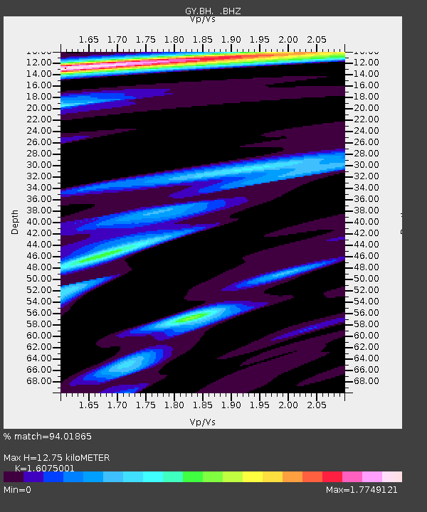
| Estimated Moho Depth: |
12.75 km |
| Estimated Crust Vp/Vs: |
1.61 |
| Assumed Crust Vp: |
6.53 km/s |
| Estimated Crust Vs: |
4.062 km/s |
| Estimated Crust Poisson's Ratio: |
0.18 |
|
| Radial Match: |
94.01865 % |
| Radial Bump: |
400 |
| Transverse Match: |
82.72663 % |
| Transverse Bump: |
400 |
| SOD ConfigId: |
4480 |
| Insert Time: |
2010-03-09 13:53:57.020 +0000 |
| GWidth: |
2.5 |
| Max Bumps: |
400 |
| Tol: |
0.001 |
|

Signal To Noise
| Channel | StoN | STA | LTA |
| GY:BH: :BHZ:19940820T04:48:59.050012Z | 37.171238 | 1624.5767 | 43.705208 |
| GY:BH: :BHN:19940820T04:48:59.050012Z | 9.94347 | 328.47183 | 33.033924 |
| GY:BH: :BHE:19940820T04:48:59.050012Z | 8.280025 | 315.9959 | 38.163643 |
| Arrivals |
| Ps | 1.2 SECOND |
| PpPs | 4.9 SECOND |
| PsPs/PpSs | 6.1 SECOND |


