You are here: Home > Network List > CN - Canadian National Seismograph Network Stations List
> Station INK INUVIK, NT > Earthquake Result Viewer
INK INUVIK, NT - Earthquake Result Viewer
*The percent match for this event was below the threshold and hence no stack was calculated.
| Earthquake location: |
Fiji Islands Region |
| Earthquake latitude/longitude: |
-19.6/-177.6 |
| Earthquake time(UTC): |
2021/10/30 (303) 08:05:19 GMT |
| Earthquake Depth: |
379 km |
| Earthquake Magnitude: |
5.5 mww |
| Earthquake Catalog/Contributor: |
NEIC PDE/us |
|
| Network: |
CN Canadian National Seismograph Network |
| Station: |
INK INUVIK, NT |
| Lat/Lon: |
68.31 N/133.53 W |
| Elevation: |
44 m |
|
| Distance: |
93.3 deg |
| Az: |
15.025 deg |
| Baz: |
221.093 deg |
| Ray Param: |
$rayparam |
*The percent match for this event was below the threshold and hence was not used in the summary stack. |
|
| Radial Match: |
40.731434 % |
| Radial Bump: |
382 |
| Transverse Match: |
56.039738 % |
| Transverse Bump: |
370 |
| SOD ConfigId: |
26497111 |
| Insert Time: |
2021-11-13 08:13:49.768 +0000 |
| GWidth: |
2.5 |
| Max Bumps: |
400 |
| Tol: |
0.001 |
|
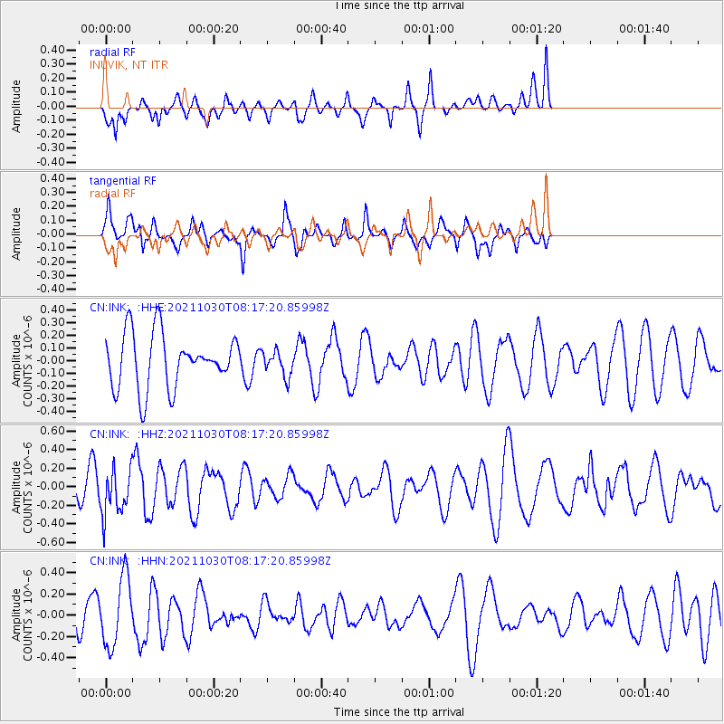
Signal To Noise
| Channel | StoN | STA | LTA |
| CN:INK: :HHZ:20211030T08:17:20.85998Z | 1.3131793 | 2.4058582E-7 | 1.8320866E-7 |
| CN:INK: :HHN:20211030T08:17:20.85998Z | 1.9013773 | 3.2770112E-7 | 1.7234933E-7 |
| CN:INK: :HHE:20211030T08:17:20.85998Z | 0.46796715 | 9.973583E-8 | 2.131257E-7 |
| Arrivals |
| Ps | |
| PpPs | |
| PsPs/PpSs | |


