You are here: Home > Network List > TX - Texas Seismological Network Stations List
> Station WTFS Witchita Falls > Earthquake Result Viewer
WTFS Witchita Falls - Earthquake Result Viewer
*The percent match for this event was below the threshold and hence no stack was calculated.
| Earthquake location: |
Tonga Islands |
| Earthquake latitude/longitude: |
-15.5/-174.5 |
| Earthquake time(UTC): |
2018/04/22 (112) 16:59:16 GMT |
| Earthquake Depth: |
10 km |
| Earthquake Magnitude: |
5.6 Mww |
| Earthquake Catalog/Contributor: |
NEIC PDE/us |
|
| Network: |
TX Texas Seismological Network |
| Station: |
WTFS Witchita Falls |
| Lat/Lon: |
33.77 N/98.46 W |
| Elevation: |
277 m |
|
| Distance: |
87.3 deg |
| Az: |
54.024 deg |
| Baz: |
249.513 deg |
| Ray Param: |
$rayparam |
*The percent match for this event was below the threshold and hence was not used in the summary stack. |
|
| Radial Match: |
65.31223 % |
| Radial Bump: |
400 |
| Transverse Match: |
64.79643 % |
| Transverse Bump: |
400 |
| SOD ConfigId: |
2665671 |
| Insert Time: |
2018-05-06 17:03:05.355 +0000 |
| GWidth: |
2.5 |
| Max Bumps: |
400 |
| Tol: |
0.001 |
|
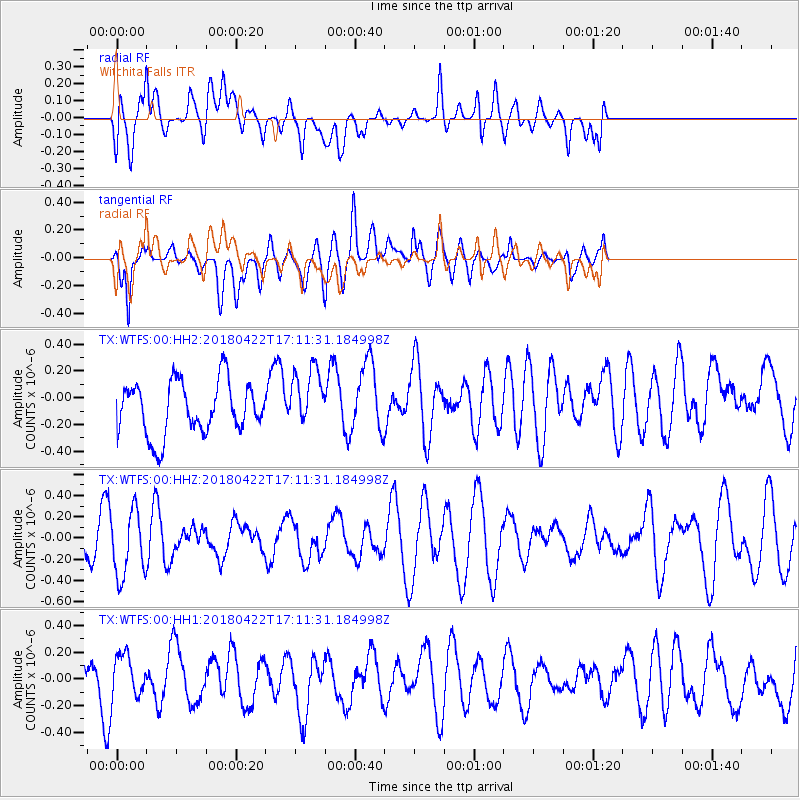
Signal To Noise
| Channel | StoN | STA | LTA |
| TX:WTFS:00:HHZ:20180422T17:11:31.184998Z | 1.601205 | 3.0478824E-7 | 1.9034928E-7 |
| TX:WTFS:00:HH1:20180422T17:11:31.184998Z | 0.6613489 | 1.593475E-7 | 2.4094317E-7 |
| TX:WTFS:00:HH2:20180422T17:11:31.184998Z | 1.1131674 | 2.202228E-7 | 1.978344E-7 |
| Arrivals |
| Ps | |
| PpPs | |
| PsPs/PpSs | |


