You are here: Home > Network List > US - United States National Seismic Network Stations List
> Station HLID Hailey, Idaho, USA > Earthquake Result Viewer
HLID Hailey, Idaho, USA - Earthquake Result Viewer
*The percent match for this event was below the threshold and hence no stack was calculated.
| Earthquake location: |
Tonga Islands |
| Earthquake latitude/longitude: |
-15.5/-174.5 |
| Earthquake time(UTC): |
2018/04/22 (112) 16:59:16 GMT |
| Earthquake Depth: |
10 km |
| Earthquake Magnitude: |
5.6 Mww |
| Earthquake Catalog/Contributor: |
NEIC PDE/us |
|
| Network: |
US United States National Seismic Network |
| Station: |
HLID Hailey, Idaho, USA |
| Lat/Lon: |
43.56 N/114.41 W |
| Elevation: |
1772 m |
|
| Distance: |
80.3 deg |
| Az: |
39.72 deg |
| Baz: |
237.96 deg |
| Ray Param: |
$rayparam |
*The percent match for this event was below the threshold and hence was not used in the summary stack. |
|
| Radial Match: |
74.09808 % |
| Radial Bump: |
400 |
| Transverse Match: |
39.79531 % |
| Transverse Bump: |
400 |
| SOD ConfigId: |
2665671 |
| Insert Time: |
2018-05-06 17:03:28.676 +0000 |
| GWidth: |
2.5 |
| Max Bumps: |
400 |
| Tol: |
0.001 |
|
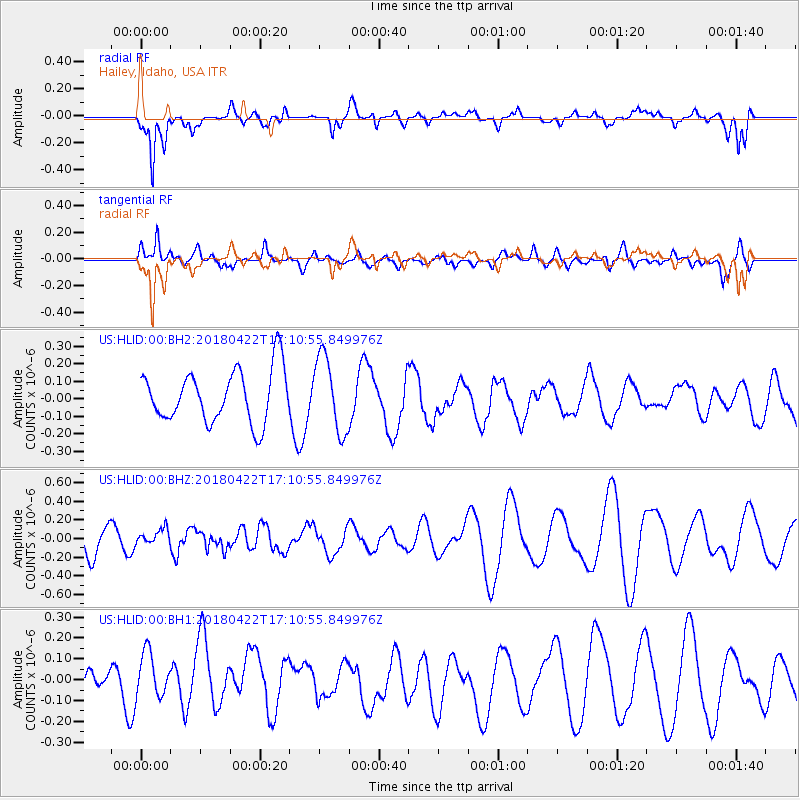
Signal To Noise
| Channel | StoN | STA | LTA |
| US:HLID:00:BHZ:20180422T17:10:55.849976Z | 0.65710217 | 8.062059E-8 | 1.226911E-7 |
| US:HLID:00:BH1:20180422T17:10:55.849976Z | 0.7084179 | 1.16595146E-7 | 1.6458526E-7 |
| US:HLID:00:BH2:20180422T17:10:55.849976Z | 1.4585782 | 2.1688936E-7 | 1.4869917E-7 |
| Arrivals |
| Ps | |
| PpPs | |
| PsPs/PpSs | |


