You are here: Home > Network List > AZ - ANZA Regional Network Stations List
> Station FRD AZ.FRD > Earthquake Result Viewer
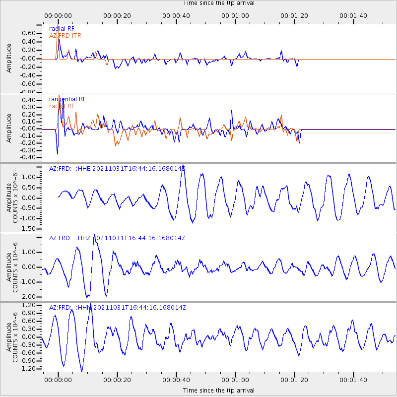
FRD AZ.FRD - Earthquake Result Viewer
*The percent match for this event was below the threshold and hence no stack was calculated.
| Earthquake location: |
South Of Alaska |
| Earthquake latitude/longitude: |
54.9/-158.7 |
| Earthquake time(UTC): |
2021/10/31 (304) 16:37:45 GMT |
| Earthquake Depth: |
21 km |
| Earthquake Magnitude: |
5.6 Mww |
| Earthquake Catalog/Contributor: |
NEIC PDE/us |
|
| Network: |
AZ ANZA Regional Network |
| Station: |
FRD AZ.FRD |
| Lat/Lon: |
33.49 N/116.60 W |
| Elevation: |
1164 m |
|
| Distance: |
36.2 deg |
| Az: |
108.674 deg |
| Baz: |
319.105 deg |
| Ray Param: |
$rayparam |
*The percent match for this event was below the threshold and hence was not used in the summary stack. |
|
| Radial Match: |
64.01126 % |
| Radial Bump: |
400 |
| Transverse Match: |
72.03003 % |
| Transverse Bump: |
400 |
| SOD ConfigId: |
26497111 |
| Insert Time: |
2021-11-14 16:39:53.682 +0000 |
| GWidth: |
2.5 |
| Max Bumps: |
400 |
| Tol: |
0.001 |
|
Signal To Noise
| Channel | StoN | STA | LTA |
| AZ:FRD: :HHZ:20211031T16:44:16.168014Z | 2.4834936 | 6.575395E-7 | 2.6476394E-7 |
| AZ:FRD: :HHN:20211031T16:44:16.168014Z | 2.699317 | 7.460321E-7 | 2.7637807E-7 |
| AZ:FRD: :HHE:20211031T16:44:16.168014Z | 1.4501513 | 3.5043058E-7 | 2.4165104E-7 |
| Arrivals |
| Ps | |
| PpPs | |
| PsPs/PpSs | |


