You are here: Home > Network List > GY - Geyokcha, Turkmenistan Seismic Array Stations List
> Station D32 GY.D32 > Earthquake Result Viewer
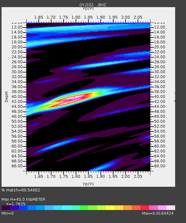
D32 GY.D32 - Earthquake Result Viewer
| Earthquake location: |
Philippine Islands Region |
| Earthquake latitude/longitude: |
10.2/126.5 |
| Earthquake time(UTC): |
1993/11/29 (333) 20:28:43 GMT |
| Earthquake Depth: |
33 km |
| Earthquake Magnitude: |
5.6 MB, 5.7 MS |
| Earthquake Catalog/Contributor: |
WHDF/NEIC |
|
| Network: |
GY Geyokcha, Turkmenistan Seismic Array |
| Station: |
D32 GY.D32 |
| Lat/Lon: |
37.93 N/58.11 E |
| Elevation: |
663 m |
|
| Distance: |
66.7 deg |
| Az: |
306.85 deg |
| Baz: |
95.124 deg |
| Ray Param: |
0.05735919 |
| Estimated Moho Depth: |
40.0 km |
| Estimated Crust Vp/Vs: |
1.79 |
| Assumed Crust Vp: |
6.53 km/s |
| Estimated Crust Vs: |
3.643 km/s |
| Estimated Crust Poisson's Ratio: |
0.27 |
|
| Radial Match: |
88.54882 % |
| Radial Bump: |
400 |
| Transverse Match: |
62.257404 % |
| Transverse Bump: |
400 |
| SOD ConfigId: |
4480 |
| Insert Time: |
2010-03-09 13:54:55.516 +0000 |
| GWidth: |
2.5 |
| Max Bumps: |
400 |
| Tol: |
0.001 |
|

Signal To Noise
| Channel | StoN | STA | LTA |
| GY:D32: :BHZ:19931129T20:39:00.498999Z | 5.4822154 | 295.531 | 53.907223 |
| GY:D32: :BHN:19931129T20:39:00.498999Z | 0.6220607 | 42.3509 | 68.08162 |
| GY:D32: :BHE:19931129T20:39:00.498999Z | 3.2848155 | 155.93808 | 47.4724 |
| Arrivals |
| Ps | 5.1 SECOND |
| PpPs | 16 SECOND |
| PsPs/PpSs | 21 SECOND |


