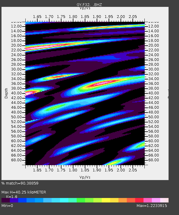
F32 GY.F32 - Earthquake Result Viewer

Earthquake location: Nicobar Islands, India Region
Earthquake latitude/longitude: 6.5/94.7
Earthquake time(UTC): 1993/08/28 (240) 20:14:44 GMT
Earthquake Depth: 120 km
Earthquake Magnitude: 5.8 MB, 5.9 UNKNOWN, 5.9 MW
Earthquake Catalog/Contributor: WHDF/NEIC
Network: GY Geyokcha, Turkmenistan Seismic Array
Station: F32 GY.F32
Lat/Lon: 37.93 N/58.11 E
Elevation: 663 m
Distance: 45.6 deg
Az: 318.687 deg
Baz: 123.951 deg
Ray Param: 0.07076473
Estimated Moho Depth: 40.25 km
Estimated Crust Vp/Vs: 1.60
Assumed Crust Vp: 6.53 km/s
Estimated Crust Vs: 4.082 km/s
Estimated Crust Poisson's Ratio: 0.18
Radial Match: 90.38859 %
Radial Bump: 400
Transverse Match: 87.11411 %
Transverse Bump: 400
SOD ConfigId: 4480
Insert Time: 2010-03-09 13:56:05.748 +0000
GWidth: 2.5
Max Bumps: 400
Tol: 0.001

Signal To Noise

ChannelStoNSTALTA
GY:F32: :BHZ:19930828T20:22:22.000006Z17.143261578.273733.73184
GY:F32: :BHN:19930828T20:22:22.000006Z6.192334165.9955126.806614
GY:F32: :BHE:19930828T20:22:22.000006Z7.8414493231.6379529.540197
Arrivals
Ps4.0 SECOND
PpPs15 SECOND
PsPs/PpSs19 SECOND