You are here: Home > Network List > N4 - Central and EAstern US Network Stations List
> Station S51A Beattyville, KY, USA > Earthquake Result Viewer
S51A Beattyville, KY, USA - Earthquake Result Viewer
| Earthquake location: |
Chile-Argentina Border Region |
| Earthquake latitude/longitude: |
-32.7/-70.1 |
| Earthquake time(UTC): |
2021/11/03 (307) 03:17:48 GMT |
| Earthquake Depth: |
98 km |
| Earthquake Magnitude: |
5.7 mww |
| Earthquake Catalog/Contributor: |
NEIC PDE/us |
|
| Network: |
N4 Central and EAstern US Network |
| Station: |
S51A Beattyville, KY, USA |
| Lat/Lon: |
37.64 N/83.59 W |
| Elevation: |
286 m |
|
| Distance: |
71.1 deg |
| Az: |
348.671 deg |
| Baz: |
167.957 deg |
| Ray Param: |
0.054314714 |
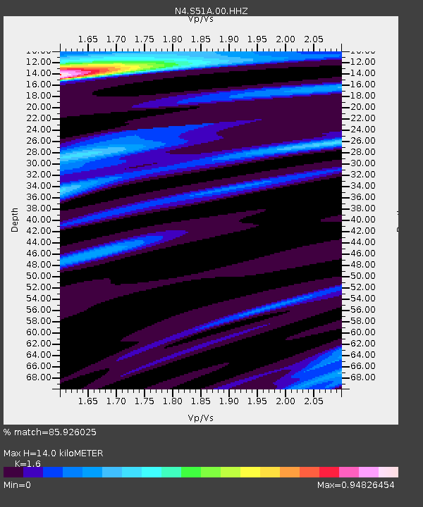
| Estimated Moho Depth: |
14.0 km |
| Estimated Crust Vp/Vs: |
1.60 |
| Assumed Crust Vp: |
6.476 km/s |
| Estimated Crust Vs: |
4.047 km/s |
| Estimated Crust Poisson's Ratio: |
0.18 |
|
| Radial Match: |
85.926025 % |
| Radial Bump: |
342 |
| Transverse Match: |
70.148544 % |
| Transverse Bump: |
400 |
| SOD ConfigId: |
26694651 |
| Insert Time: |
2021-11-17 03:25:33.516 +0000 |
| GWidth: |
2.5 |
| Max Bumps: |
400 |
| Tol: |
0.001 |
|

Signal To Noise
| Channel | StoN | STA | LTA |
| N4:S51A:00:HHZ:20211103T03:28:25.269009Z | 1.3625268 | 1.780929E-6 | 1.3070782E-6 |
| N4:S51A:00:HH1:20211103T03:28:25.269009Z | 1.6263905 | 1.1013015E-6 | 6.771446E-7 |
| N4:S51A:00:HH2:20211103T03:28:25.269009Z | 0.522226 | 2.2732283E-7 | 4.352959E-7 |
| Arrivals |
| Ps | 1.4 SECOND |
| PpPs | 5.4 SECOND |
| PsPs/PpSs | 6.7 SECOND |


