You are here: Home > Network List > GY - Geyokcha, Turkmenistan Seismic Array Stations List
> Station FH GY.FH > Earthquake Result Viewer
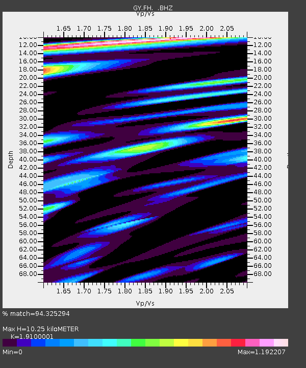
FH GY.FH - Earthquake Result Viewer
| Earthquake location: |
Ryukyu Islands, Japan |
| Earthquake latitude/longitude: |
29.3/129.9 |
| Earthquake time(UTC): |
1994/09/13 (256) 04:28:01 GMT |
| Earthquake Depth: |
37 km |
| Earthquake Magnitude: |
5.8 MB, 6.3 MS, 6.2 UNKNOWN, 6.1 MW |
| Earthquake Catalog/Contributor: |
WHDF/NEIC |
|
| Network: |
GY Geyokcha, Turkmenistan Seismic Array |
| Station: |
FH GY.FH |
| Lat/Lon: |
37.93 N/58.11 E |
| Elevation: |
663 m |
|
| Distance: |
59.1 deg |
| Az: |
298.89 deg |
| Baz: |
75.343 deg |
| Ray Param: |
0.06236755 |
| Estimated Moho Depth: |
10.25 km |
| Estimated Crust Vp/Vs: |
1.91 |
| Assumed Crust Vp: |
6.53 km/s |
| Estimated Crust Vs: |
3.419 km/s |
| Estimated Crust Poisson's Ratio: |
0.31 |
|
| Radial Match: |
94.325294 % |
| Radial Bump: |
400 |
| Transverse Match: |
83.21911 % |
| Transverse Bump: |
400 |
| SOD ConfigId: |
4480 |
| Insert Time: |
2010-03-09 13:56:42.252 +0000 |
| GWidth: |
2.5 |
| Max Bumps: |
400 |
| Tol: |
0.001 |
|

Signal To Noise
| Channel | StoN | STA | LTA |
| GY:FH: :BHZ:19940913T04:37:26.700012Z | 6.95946 | 327.8215 | 47.10445 |
| GY:FH: :BHN:19940913T04:37:26.700012Z | 1.6222658 | 49.184967 | 30.318687 |
| GY:FH: :BHE:19940913T04:37:26.700012Z | 3.967017 | 110.613 | 27.88317 |
| Arrivals |
| Ps | 1.5 SECOND |
| PpPs | 4.4 SECOND |
| PsPs/PpSs | 5.9 SECOND |


