You are here: Home > Network List > US - United States National Seismic Network Stations List
> Station LONY Lake Ozonia, New York, USA > Earthquake Result Viewer
LONY Lake Ozonia, New York, USA - Earthquake Result Viewer
| Earthquake location: |
Chile-Argentina Border Region |
| Earthquake latitude/longitude: |
-32.7/-70.1 |
| Earthquake time(UTC): |
2021/11/03 (307) 03:17:48 GMT |
| Earthquake Depth: |
98 km |
| Earthquake Magnitude: |
5.7 mww |
| Earthquake Catalog/Contributor: |
NEIC PDE/us |
|
| Network: |
US United States National Seismic Network |
| Station: |
LONY Lake Ozonia, New York, USA |
| Lat/Lon: |
44.62 N/74.58 W |
| Elevation: |
440 m |
|
| Distance: |
77.1 deg |
| Az: |
356.683 deg |
| Baz: |
176.082 deg |
| Ray Param: |
0.05035229 |
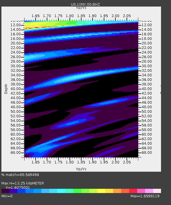
| Estimated Moho Depth: |
13.25 km |
| Estimated Crust Vp/Vs: |
1.61 |
| Assumed Crust Vp: |
6.419 km/s |
| Estimated Crust Vs: |
3.993 km/s |
| Estimated Crust Poisson's Ratio: |
0.18 |
|
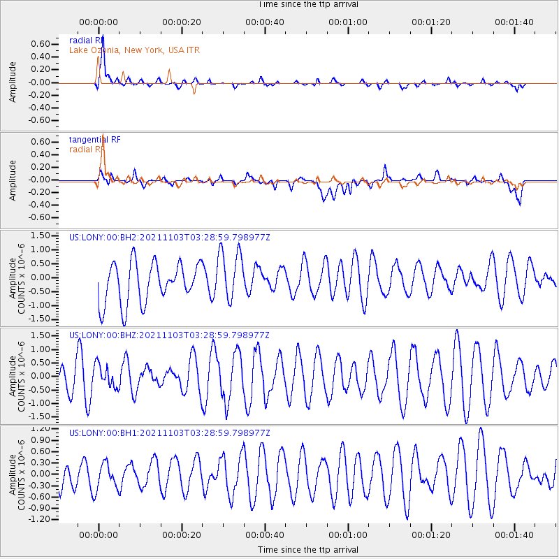
| Radial Match: |
88.569496 % |
| Radial Bump: |
400 |
| Transverse Match: |
47.817677 % |
| Transverse Bump: |
400 |
| SOD ConfigId: |
26694651 |
| Insert Time: |
2021-11-17 03:31:47.681 +0000 |
| GWidth: |
2.5 |
| Max Bumps: |
400 |
| Tol: |
0.001 |
|
Signal To Noise
| Channel | StoN | STA | LTA |
| US:LONY:00:BHZ:20211103T03:28:59.798977Z | 0.5848613 | 4.1603602E-7 | 7.1134133E-7 |
| US:LONY:00:BH1:20211103T03:28:59.798977Z | 0.4982393 | 3.3557703E-7 | 6.735258E-7 |
| US:LONY:00:BH2:20211103T03:28:59.798977Z | 1.2910539 | 9.2891116E-7 | 7.1949836E-7 |
| Arrivals |
| Ps | 1.3 SECOND |
| PpPs | 5.2 SECOND |
| PsPs/PpSs | 6.5 SECOND |


