You are here: Home > Network List > AK - Alaska Regional Network Stations List
> Station CUT Chulitna, AK, USA > Earthquake Result Viewer
CUT Chulitna, AK, USA - Earthquake Result Viewer
*The percent match for this event was below the threshold and hence no stack was calculated.
| Earthquake location: |
South Of Tonga Islands |
| Earthquake latitude/longitude: |
-24.5/-175.9 |
| Earthquake time(UTC): |
2021/11/03 (307) 03:19:00 GMT |
| Earthquake Depth: |
35 km |
| Earthquake Magnitude: |
5.7 mww |
| Earthquake Catalog/Contributor: |
NEIC PDE/us |
|
| Network: |
AK Alaska Regional Network |
| Station: |
CUT Chulitna, AK, USA |
| Lat/Lon: |
62.41 N/150.26 W |
| Elevation: |
574 m |
|
| Distance: |
89.0 deg |
| Az: |
11.63 deg |
| Baz: |
203.231 deg |
| Ray Param: |
$rayparam |
*The percent match for this event was below the threshold and hence was not used in the summary stack. |
|
| Radial Match: |
52.399315 % |
| Radial Bump: |
400 |
| Transverse Match: |
53.791595 % |
| Transverse Bump: |
400 |
| SOD ConfigId: |
26694651 |
| Insert Time: |
2021-11-17 03:35:07.991 +0000 |
| GWidth: |
2.5 |
| Max Bumps: |
400 |
| Tol: |
0.001 |
|
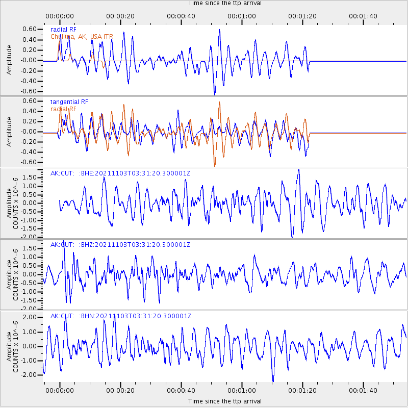
Signal To Noise
| Channel | StoN | STA | LTA |
| AK:CUT: :BHZ:20211103T03:31:20.300001Z | 2.107005 | 8.755428E-7 | 4.1553903E-7 |
| AK:CUT: :BHN:20211103T03:31:20.300001Z | 1.4328167 | 1.0088974E-6 | 7.041357E-7 |
| AK:CUT: :BHE:20211103T03:31:20.300001Z | 0.57388055 | 3.3662764E-7 | 5.8658134E-7 |
| Arrivals |
| Ps | |
| PpPs | |
| PsPs/PpSs | |


