You are here: Home > Network List > IW - Intermountain West Stations List
> Station MOOW Moose Ponds, Wyoming, USA > Earthquake Result Viewer
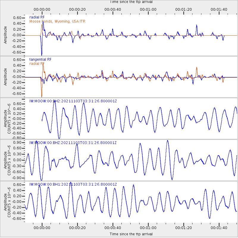
MOOW Moose Ponds, Wyoming, USA - Earthquake Result Viewer
*The percent match for this event was below the threshold and hence no stack was calculated.
| Earthquake location: |
South Of Tonga Islands |
| Earthquake latitude/longitude: |
-24.5/-175.9 |
| Earthquake time(UTC): |
2021/11/03 (307) 03:19:00 GMT |
| Earthquake Depth: |
35 km |
| Earthquake Magnitude: |
5.7 mww |
| Earthquake Catalog/Contributor: |
NEIC PDE/us |
|
| Network: |
IW Intermountain West |
| Station: |
MOOW Moose Ponds, Wyoming, USA |
| Lat/Lon: |
43.75 N/110.74 W |
| Elevation: |
2128 m |
|
| Distance: |
90.4 deg |
| Az: |
41.124 deg |
| Baz: |
235.782 deg |
| Ray Param: |
$rayparam |
*The percent match for this event was below the threshold and hence was not used in the summary stack. |
|
| Radial Match: |
73.08453 % |
| Radial Bump: |
400 |
| Transverse Match: |
51.17693 % |
| Transverse Bump: |
400 |
| SOD ConfigId: |
26694651 |
| Insert Time: |
2021-11-17 03:43:36.822 +0000 |
| GWidth: |
2.5 |
| Max Bumps: |
400 |
| Tol: |
0.001 |
|
Signal To Noise
| Channel | StoN | STA | LTA |
| IW:MOOW:00:BHZ:20211103T03:31:26.800001Z | 2.2317634 | 6.196943E-7 | 2.7767027E-7 |
| IW:MOOW:00:BH1:20211103T03:31:26.800001Z | 1.6340439 | 3.849883E-7 | 2.3560463E-7 |
| IW:MOOW:00:BH2:20211103T03:31:26.800001Z | 0.51287663 | 2.080166E-7 | 4.05588E-7 |
| Arrivals |
| Ps | |
| PpPs | |
| PsPs/PpSs | |


