You are here: Home > Network List > US - United States National Seismic Network Stations List
> Station DGMT Dagmar, Montana, USA > Earthquake Result Viewer
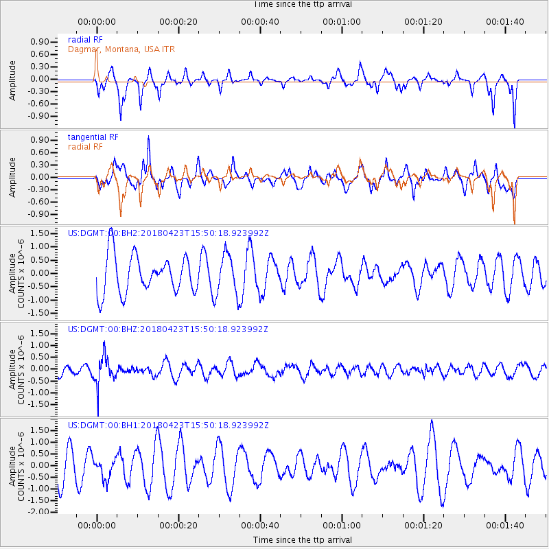
DGMT Dagmar, Montana, USA - Earthquake Result Viewer
*The percent match for this event was below the threshold and hence no stack was calculated.
| Earthquake location: |
Colombia |
| Earthquake latitude/longitude: |
5.2/-75.5 |
| Earthquake time(UTC): |
2018/04/23 (113) 15:42:10 GMT |
| Earthquake Depth: |
113 km |
| Earthquake Magnitude: |
5.2 Mww |
| Earthquake Catalog/Contributor: |
NEIC PDE/us |
|
| Network: |
US United States National Seismic Network |
| Station: |
DGMT Dagmar, Montana, USA |
| Lat/Lon: |
48.47 N/104.20 W |
| Elevation: |
0.0 m |
|
| Distance: |
49.6 deg |
| Az: |
335.211 deg |
| Baz: |
141.135 deg |
| Ray Param: |
$rayparam |
*The percent match for this event was below the threshold and hence was not used in the summary stack. |
|
| Radial Match: |
44.864563 % |
| Radial Bump: |
275 |
| Transverse Match: |
55.46494 % |
| Transverse Bump: |
400 |
| SOD ConfigId: |
2665671 |
| Insert Time: |
2018-05-07 15:51:58.036 +0000 |
| GWidth: |
2.5 |
| Max Bumps: |
400 |
| Tol: |
0.001 |
|
Signal To Noise
| Channel | StoN | STA | LTA |
| US:DGMT:00:BHZ:20180423T15:50:18.923992Z | 3.2194943 | 5.971352E-7 | 1.8547485E-7 |
| US:DGMT:00:BH1:20180423T15:50:18.923992Z | 0.72599965 | 4.26138E-7 | 5.8696725E-7 |
| US:DGMT:00:BH2:20180423T15:50:18.923992Z | 1.0622641 | 7.5735807E-7 | 7.129659E-7 |
| Arrivals |
| Ps | |
| PpPs | |
| PsPs/PpSs | |


