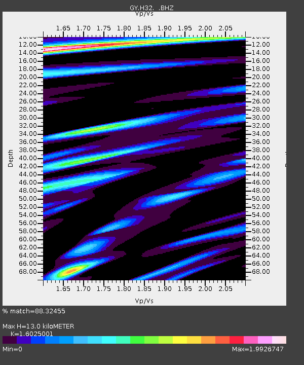
H32 GY.H32 - Earthquake Result Viewer

Earthquake location: Southeast Of Honshu, Japan
Earthquake latitude/longitude: 32.0/137.9
Earthquake time(UTC): 1993/10/11 (284) 15:54:22 GMT
Earthquake Depth: 365 km
Earthquake Magnitude: 6.5 MB, 6.8 UNKNOWN, 6.9 MW
Earthquake Catalog/Contributor: WHDF/NEIC
Network: GY Geyokcha, Turkmenistan Seismic Array
Station: H32 GY.H32
Lat/Lon: 37.93 N/58.11 E
Elevation: 663 m
Distance: 63.7 deg
Az: 299.808 deg
Baz: 68.791 deg
Ray Param: 0.05816445
Estimated Moho Depth: 13.0 km
Estimated Crust Vp/Vs: 1.60
Assumed Crust Vp: 6.53 km/s
Estimated Crust Vs: 4.075 km/s
Estimated Crust Poisson's Ratio: 0.18
Radial Match: 88.32455 %
Radial Bump: 400
Transverse Match: 79.415375 %
Transverse Bump: 400
SOD ConfigId: 4480
Insert Time: 2010-03-09 13:57:42.563 +0000
GWidth: 2.5
Max Bumps: 400
Tol: 0.001

Signal To Noise

ChannelStoNSTALTA
GY:H32: :BHZ:19931011T16:03:45.600012Z51.619783820.11174.00479
GY:H32: :BHN:19931011T16:03:45.600012Z15.562171502.1509432.26741
GY:H32: :BHE:19931011T16:03:45.600012Z29.4140621062.44836.120407
Arrivals
Ps1.3 SECOND
PpPs4.9 SECOND
PsPs/PpSs6.2 SECOND