You are here: Home > Network List > US - United States National Seismic Network Stations List
> Station CBKS Cedar Bluff, Kansas, USA > Earthquake Result Viewer
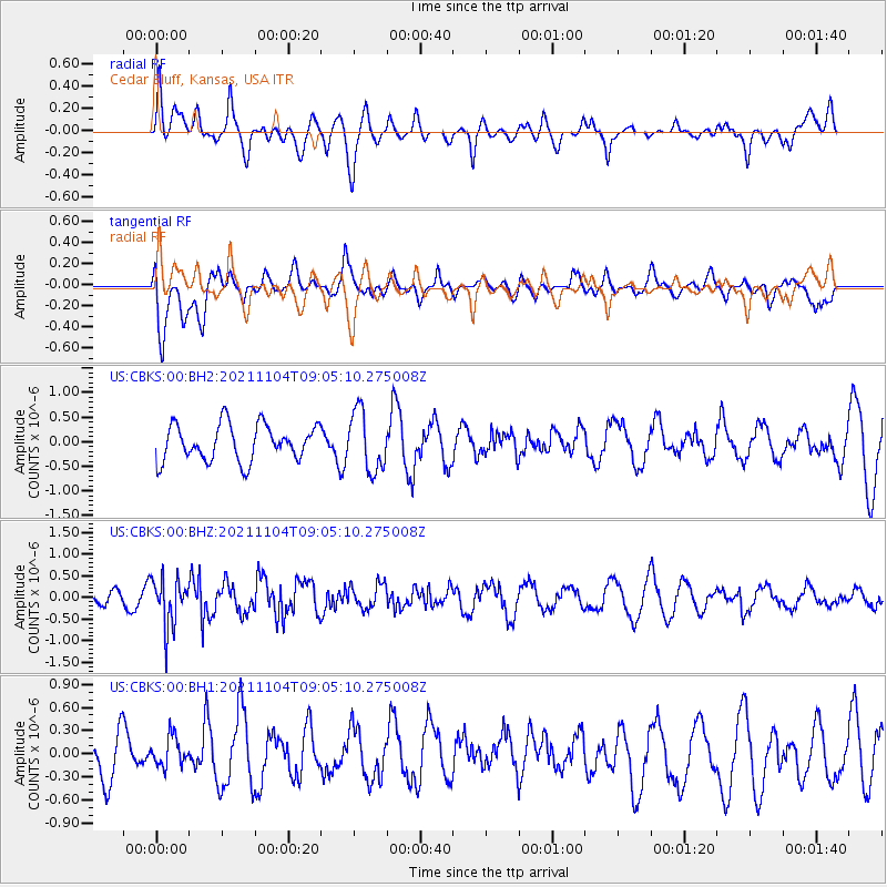
CBKS Cedar Bluff, Kansas, USA - Earthquake Result Viewer
*The percent match for this event was below the threshold and hence no stack was calculated.
| Earthquake location: |
Fox Islands, Aleutian Islands |
| Earthquake latitude/longitude: |
52.7/-168.0 |
| Earthquake time(UTC): |
2021/11/04 (308) 08:57:06 GMT |
| Earthquake Depth: |
36 km |
| Earthquake Magnitude: |
5.2 Mww |
| Earthquake Catalog/Contributor: |
NEIC PDE/us |
|
| Network: |
US United States National Seismic Network |
| Station: |
CBKS Cedar Bluff, Kansas, USA |
| Lat/Lon: |
38.81 N/99.74 W |
| Elevation: |
677 m |
|
| Distance: |
47.8 deg |
| Az: |
78.312 deg |
| Baz: |
310.287 deg |
| Ray Param: |
$rayparam |
*The percent match for this event was below the threshold and hence was not used in the summary stack. |
|
| Radial Match: |
66.914444 % |
| Radial Bump: |
400 |
| Transverse Match: |
73.96175 % |
| Transverse Bump: |
400 |
| SOD ConfigId: |
26694651 |
| Insert Time: |
2021-11-18 09:14:33.104 +0000 |
| GWidth: |
2.5 |
| Max Bumps: |
400 |
| Tol: |
0.001 |
|
Signal To Noise
| Channel | StoN | STA | LTA |
| US:CBKS:00:BHZ:20211104T09:05:10.275008Z | 2.748428 | 5.5296744E-7 | 2.0119407E-7 |
| US:CBKS:00:BH1:20211104T09:05:10.275008Z | 0.7148561 | 2.0456595E-7 | 2.861638E-7 |
| US:CBKS:00:BH2:20211104T09:05:10.275008Z | 1.6637195 | 6.0766513E-7 | 3.6524494E-7 |
| Arrivals |
| Ps | |
| PpPs | |
| PsPs/PpSs | |


