You are here: Home > Network List > MM - Myanmar National Seismic Network Stations List
> Station NGU Ngaung U, Myanmar > Earthquake Result Viewer
NGU Ngaung U, Myanmar - Earthquake Result Viewer
| Earthquake location: |
Southern Molucca Sea |
| Earthquake latitude/longitude: |
-0.1/124.3 |
| Earthquake time(UTC): |
2021/11/06 (310) 14:37:37 GMT |
| Earthquake Depth: |
40 km |
| Earthquake Magnitude: |
6.0 mww |
| Earthquake Catalog/Contributor: |
NEIC PDE/us |
|
| Network: |
MM Myanmar National Seismic Network |
| Station: |
NGU Ngaung U, Myanmar |
| Lat/Lon: |
21.21 N/94.92 E |
| Elevation: |
70 m |
|
| Distance: |
35.7 deg |
| Az: |
308.218 deg |
| Baz: |
122.649 deg |
| Ray Param: |
0.07702617 |
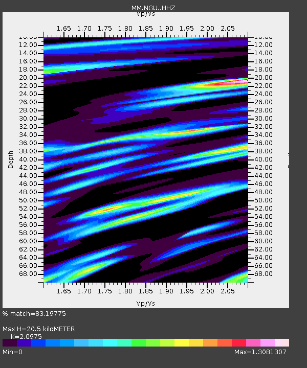
| Estimated Moho Depth: |
20.5 km |
| Estimated Crust Vp/Vs: |
2.10 |
| Assumed Crust Vp: |
6.036 km/s |
| Estimated Crust Vs: |
2.878 km/s |
| Estimated Crust Poisson's Ratio: |
0.35 |
|
| Radial Match: |
83.19775 % |
| Radial Bump: |
400 |
| Transverse Match: |
75.86061 % |
| Transverse Bump: |
400 |
| SOD ConfigId: |
26694651 |
| Insert Time: |
2021-11-20 14:45:18.518 +0000 |
| GWidth: |
2.5 |
| Max Bumps: |
400 |
| Tol: |
0.001 |
|

Signal To Noise
| Channel | StoN | STA | LTA |
| MM:NGU: :HHZ:20211106T14:44:01.350007Z | 18.258621 | 1.6086925E-6 | 8.810591E-8 |
| MM:NGU: :HHN:20211106T14:44:01.350007Z | 2.4476767 | 3.7518723E-7 | 1.53283E-7 |
| MM:NGU: :HHE:20211106T14:44:01.350007Z | 3.832578 | 3.8625646E-7 | 1.00782415E-7 |
| Arrivals |
| Ps | 3.9 SECOND |
| PpPs | 10.0 SECOND |
| PsPs/PpSs | 14 SECOND |


