You are here: Home > Network List > US - United States National Seismic Network Stations List
> Station DGMT Dagmar, Montana, USA > Earthquake Result Viewer
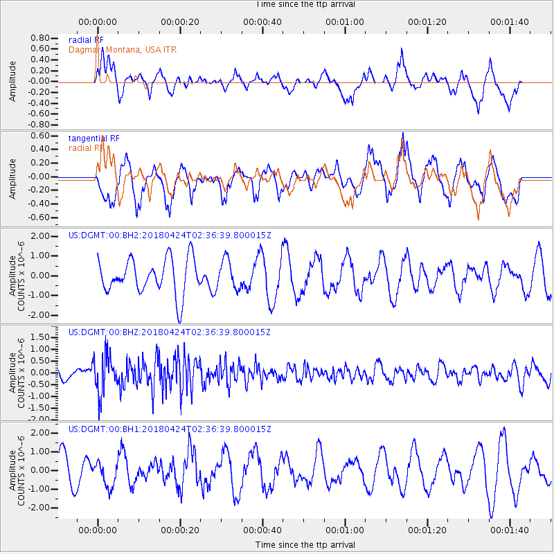
DGMT Dagmar, Montana, USA - Earthquake Result Viewer
*The percent match for this event was below the threshold and hence no stack was calculated.
| Earthquake location: |
Near Coast Of Nicaragua |
| Earthquake latitude/longitude: |
12.5/-87.8 |
| Earthquake time(UTC): |
2018/04/24 (114) 02:29:53 GMT |
| Earthquake Depth: |
47 km |
| Earthquake Magnitude: |
5.6 Mww |
| Earthquake Catalog/Contributor: |
NEIC PDE/us |
|
| Network: |
US United States National Seismic Network |
| Station: |
DGMT Dagmar, Montana, USA |
| Lat/Lon: |
48.47 N/104.20 W |
| Elevation: |
0.0 m |
|
| Distance: |
38.4 deg |
| Az: |
342.332 deg |
| Baz: |
153.556 deg |
| Ray Param: |
$rayparam |
*The percent match for this event was below the threshold and hence was not used in the summary stack. |
|
| Radial Match: |
60.04794 % |
| Radial Bump: |
400 |
| Transverse Match: |
50.789623 % |
| Transverse Bump: |
400 |
| SOD ConfigId: |
2665671 |
| Insert Time: |
2018-05-08 02:32:24.994 +0000 |
| GWidth: |
2.5 |
| Max Bumps: |
400 |
| Tol: |
0.001 |
|
Signal To Noise
| Channel | StoN | STA | LTA |
| US:DGMT:00:BHZ:20180424T02:36:39.800015Z | 3.8052292 | 8.110111E-7 | 2.1313068E-7 |
| US:DGMT:00:BH1:20180424T02:36:39.800015Z | 0.7393557 | 6.491979E-7 | 8.78059E-7 |
| US:DGMT:00:BH2:20180424T02:36:39.800015Z | 0.8366285 | 7.3945534E-7 | 8.8385144E-7 |
| Arrivals |
| Ps | |
| PpPs | |
| PsPs/PpSs | |


