You are here: Home > Network List > AV - Alaska Volcano Observatory Stations List
> Station AMKA Regional Station, Amchitka Island, Alaska > Earthquake Result Viewer
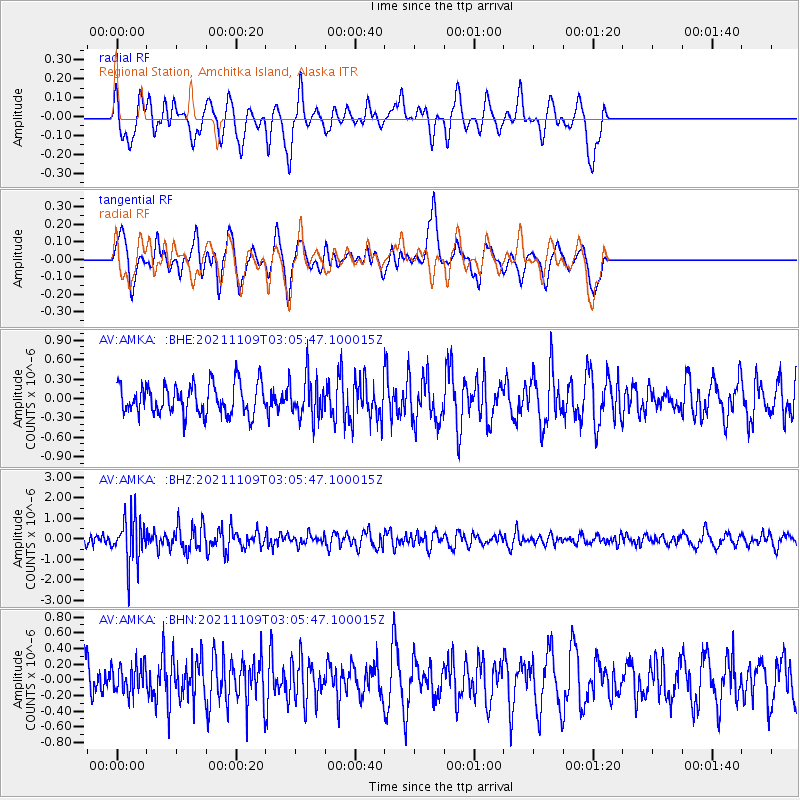
AMKA Regional Station, Amchitka Island, Alaska - Earthquake Result Viewer
*The percent match for this event was below the threshold and hence no stack was calculated.
| Earthquake location: |
Near Coast Of Nicaragua |
| Earthquake latitude/longitude: |
11.2/-86.7 |
| Earthquake time(UTC): |
2021/11/09 (313) 02:53:49 GMT |
| Earthquake Depth: |
17 km |
| Earthquake Magnitude: |
5.9 mww |
| Earthquake Catalog/Contributor: |
NEIC PDE/us |
|
| Network: |
AV Alaska Volcano Observatory |
| Station: |
AMKA Regional Station, Amchitka Island, Alaska |
| Lat/Lon: |
51.38 N/179.30 E |
| Elevation: |
116 m |
|
| Distance: |
83.9 deg |
| Az: |
321.038 deg |
| Baz: |
79.921 deg |
| Ray Param: |
$rayparam |
*The percent match for this event was below the threshold and hence was not used in the summary stack. |
|
| Radial Match: |
51.884525 % |
| Radial Bump: |
390 |
| Transverse Match: |
58.25141 % |
| Transverse Bump: |
400 |
| SOD ConfigId: |
26694651 |
| Insert Time: |
2021-11-23 02:59:06.202 +0000 |
| GWidth: |
2.5 |
| Max Bumps: |
400 |
| Tol: |
0.001 |
|
Signal To Noise
| Channel | StoN | STA | LTA |
| AV:AMKA: :BHZ:20211109T03:05:47.100015Z | 5.202879 | 1.1487977E-6 | 2.2080036E-7 |
| AV:AMKA: :BHN:20211109T03:05:47.100015Z | 0.5910003 | 1.8190242E-7 | 3.0778733E-7 |
| AV:AMKA: :BHE:20211109T03:05:47.100015Z | 1.3659818 | 3.1852932E-7 | 2.331871E-7 |
| Arrivals |
| Ps | |
| PpPs | |
| PsPs/PpSs | |


