You are here: Home > Network List > GY - Geyokcha, Turkmenistan Seismic Array Stations List
> Station SEH GY.SEH > Earthquake Result Viewer
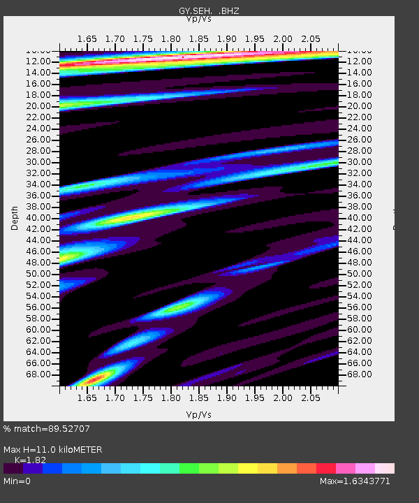
SEH GY.SEH - Earthquake Result Viewer
| Earthquake location: |
Kuril Islands |
| Earthquake latitude/longitude: |
43.6/147.1 |
| Earthquake time(UTC): |
1994/10/18 (291) 17:12:51 GMT |
| Earthquake Depth: |
66 km |
| Earthquake Magnitude: |
6.1 MB, 6.1 UNKNOWN, 5.9 MW |
| Earthquake Catalog/Contributor: |
WHDF/NEIC |
|
| Network: |
GY Geyokcha, Turkmenistan Seismic Array |
| Station: |
SEH GY.SEH |
| Lat/Lon: |
37.93 N/58.11 E |
| Elevation: |
663 m |
|
| Distance: |
64.5 deg |
| Az: |
298.856 deg |
| Baz: |
53.635 deg |
| Ray Param: |
0.058715064 |
| Estimated Moho Depth: |
11.0 km |
| Estimated Crust Vp/Vs: |
1.82 |
| Assumed Crust Vp: |
6.53 km/s |
| Estimated Crust Vs: |
3.588 km/s |
| Estimated Crust Poisson's Ratio: |
0.28 |
|
| Radial Match: |
89.52707 % |
| Radial Bump: |
400 |
| Transverse Match: |
85.16577 % |
| Transverse Bump: |
400 |
| SOD ConfigId: |
4480 |
| Insert Time: |
2010-03-09 13:59:24.501 +0000 |
| GWidth: |
2.5 |
| Max Bumps: |
400 |
| Tol: |
0.001 |
|

Signal To Noise
| Channel | StoN | STA | LTA |
| GY:SEH: :BHZ:19941018T17:22:50.600012Z | 21.20596 | 1458.939 | 68.79854 |
| GY:SEH: :BHN:19941018T17:22:50.600012Z | 6.7778006 | 307.24088 | 45.33047 |
| GY:SEH: :BHE:19941018T17:22:50.600012Z | 8.18017 | 285.23752 | 34.86939 |
| Arrivals |
| Ps | 1.4 SECOND |
| PpPs | 4.6 SECOND |
| PsPs/PpSs | 6.0 SECOND |


