You are here: Home > Network List > AV - Alaska Volcano Observatory Stations List
> Station SPCR Ckakachatna River, Mount Spurr, Alaska > Earthquake Result Viewer
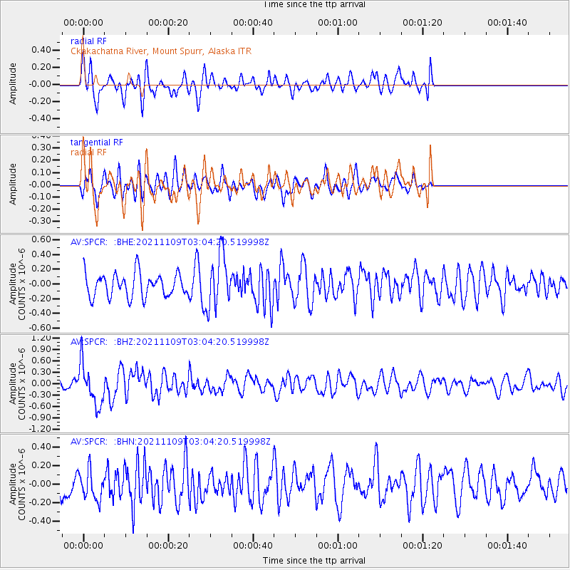
SPCR Ckakachatna River, Mount Spurr, Alaska - Earthquake Result Viewer
*The percent match for this event was below the threshold and hence no stack was calculated.
| Earthquake location: |
Near Coast Of Nicaragua |
| Earthquake latitude/longitude: |
11.2/-86.7 |
| Earthquake time(UTC): |
2021/11/09 (313) 02:53:49 GMT |
| Earthquake Depth: |
17 km |
| Earthquake Magnitude: |
5.9 mww |
| Earthquake Catalog/Contributor: |
NEIC PDE/us |
|
| Network: |
AV Alaska Volcano Observatory |
| Station: |
SPCR Ckakachatna River, Mount Spurr, Alaska |
| Lat/Lon: |
61.20 N/152.21 W |
| Elevation: |
984 m |
|
| Distance: |
68.6 deg |
| Az: |
331.745 deg |
| Baz: |
106.388 deg |
| Ray Param: |
$rayparam |
*The percent match for this event was below the threshold and hence was not used in the summary stack. |
|
| Radial Match: |
63.391407 % |
| Radial Bump: |
400 |
| Transverse Match: |
47.609703 % |
| Transverse Bump: |
400 |
| SOD ConfigId: |
26694651 |
| Insert Time: |
2021-11-23 03:00:44.255 +0000 |
| GWidth: |
2.5 |
| Max Bumps: |
400 |
| Tol: |
0.001 |
|
Signal To Noise
| Channel | StoN | STA | LTA |
| AV:SPCR: :BHZ:20211109T03:04:20.519998Z | 3.2543929 | 5.588749E-7 | 1.7172938E-7 |
| AV:SPCR: :BHN:20211109T03:04:20.519998Z | 0.81340706 | 1.5977817E-7 | 1.9643078E-7 |
| AV:SPCR: :BHE:20211109T03:04:20.519998Z | 2.2702653 | 3.6388744E-7 | 1.6028409E-7 |
| Arrivals |
| Ps | |
| PpPs | |
| PsPs/PpSs | |


