You are here: Home > Network List > N4 - Central and EAstern US Network Stations List
> Station SUSD Miller, SD, USA > Earthquake Result Viewer
SUSD Miller, SD, USA - Earthquake Result Viewer
| Earthquake location: |
Near Coast Of Nicaragua |
| Earthquake latitude/longitude: |
11.2/-86.7 |
| Earthquake time(UTC): |
2021/11/09 (313) 02:53:49 GMT |
| Earthquake Depth: |
17 km |
| Earthquake Magnitude: |
5.9 mww |
| Earthquake Catalog/Contributor: |
NEIC PDE/us |
|
| Network: |
N4 Central and EAstern US Network |
| Station: |
SUSD Miller, SD, USA |
| Lat/Lon: |
44.44 N/98.96 W |
| Elevation: |
520 m |
|
| Distance: |
34.8 deg |
| Az: |
344.537 deg |
| Baz: |
158.577 deg |
| Ray Param: |
0.07754352 |
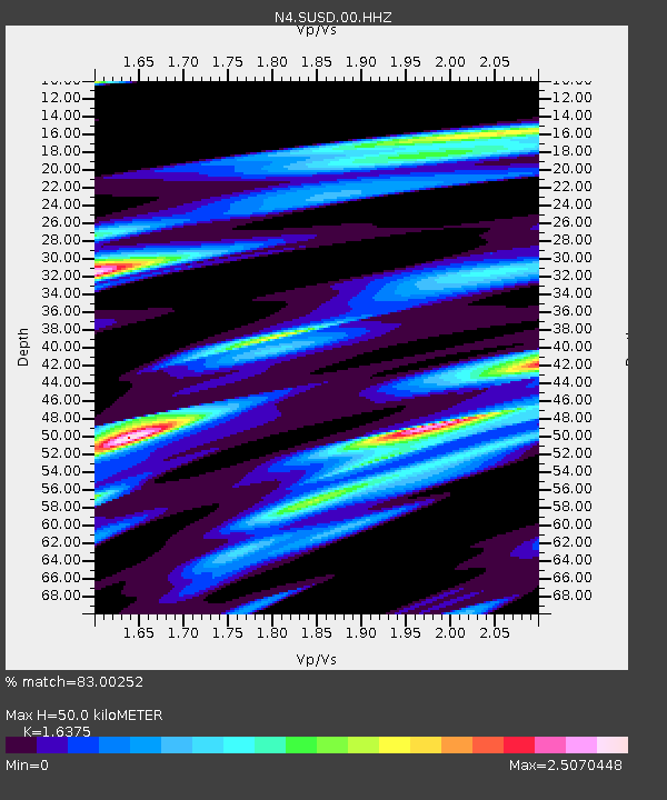
| Estimated Moho Depth: |
50.0 km |
| Estimated Crust Vp/Vs: |
1.64 |
| Assumed Crust Vp: |
6.53 km/s |
| Estimated Crust Vs: |
3.988 km/s |
| Estimated Crust Poisson's Ratio: |
0.20 |
|
| Radial Match: |
83.00252 % |
| Radial Bump: |
400 |
| Transverse Match: |
57.455177 % |
| Transverse Bump: |
400 |
| SOD ConfigId: |
26694651 |
| Insert Time: |
2021-11-23 03:10:58.744 +0000 |
| GWidth: |
2.5 |
| Max Bumps: |
400 |
| Tol: |
0.001 |
|

Signal To Noise
| Channel | StoN | STA | LTA |
| N4:SUSD:00:HHZ:20211109T03:00:08.949991Z | 6.255701 | 1.4445316E-6 | 2.3091441E-7 |
| N4:SUSD:00:HH1:20211109T03:00:08.949991Z | 7.2053146 | 2.1772469E-6 | 3.0217234E-7 |
| N4:SUSD:00:HH2:20211109T03:00:08.949991Z | 1.2700412 | 1.3552975E-6 | 1.0671288E-6 |
| Arrivals |
| Ps | 5.3 SECOND |
| PpPs | 19 SECOND |
| PsPs/PpSs | 24 SECOND |


