You are here: Home > Network List > US - United States National Seismic Network Stations List
> Station DGMT Dagmar, Montana, USA > Earthquake Result Viewer
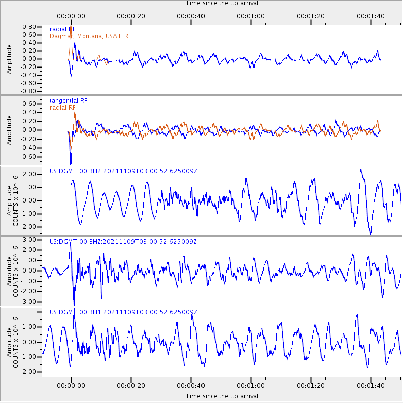
DGMT Dagmar, Montana, USA - Earthquake Result Viewer
*The percent match for this event was below the threshold and hence no stack was calculated.
| Earthquake location: |
Near Coast Of Nicaragua |
| Earthquake latitude/longitude: |
11.2/-86.7 |
| Earthquake time(UTC): |
2021/11/09 (313) 02:53:49 GMT |
| Earthquake Depth: |
17 km |
| Earthquake Magnitude: |
5.9 mww |
| Earthquake Catalog/Contributor: |
NEIC PDE/us |
|
| Network: |
US United States National Seismic Network |
| Station: |
DGMT Dagmar, Montana, USA |
| Lat/Lon: |
48.47 N/104.20 W |
| Elevation: |
0.0 m |
|
| Distance: |
40.0 deg |
| Az: |
341.842 deg |
| Baz: |
152.643 deg |
| Ray Param: |
$rayparam |
*The percent match for this event was below the threshold and hence was not used in the summary stack. |
|
| Radial Match: |
43.513287 % |
| Radial Bump: |
400 |
| Transverse Match: |
54.81929 % |
| Transverse Bump: |
400 |
| SOD ConfigId: |
26694651 |
| Insert Time: |
2021-11-23 03:14:37.729 +0000 |
| GWidth: |
2.5 |
| Max Bumps: |
400 |
| Tol: |
0.001 |
|
Signal To Noise
| Channel | StoN | STA | LTA |
| US:DGMT:00:BHZ:20211109T03:00:52.625009Z | 4.0420003 | 1.2824321E-6 | 3.172766E-7 |
| US:DGMT:00:BH1:20211109T03:00:52.625009Z | 1.9132459 | 9.211639E-7 | 4.8146654E-7 |
| US:DGMT:00:BH2:20211109T03:00:52.625009Z | 0.50698596 | 4.477972E-7 | 8.832536E-7 |
| Arrivals |
| Ps | |
| PpPs | |
| PsPs/PpSs | |


