You are here: Home > Network List > US - United States National Seismic Network Stations List
> Station GLMI Grayling, Michigan, USA > Earthquake Result Viewer
GLMI Grayling, Michigan, USA - Earthquake Result Viewer
| Earthquake location: |
Near Coast Of Nicaragua |
| Earthquake latitude/longitude: |
11.2/-86.7 |
| Earthquake time(UTC): |
2021/11/09 (313) 02:53:49 GMT |
| Earthquake Depth: |
17 km |
| Earthquake Magnitude: |
5.9 mww |
| Earthquake Catalog/Contributor: |
NEIC PDE/us |
|
| Network: |
US United States National Seismic Network |
| Station: |
GLMI Grayling, Michigan, USA |
| Lat/Lon: |
44.82 N/84.62 W |
| Elevation: |
387 m |
|
| Distance: |
33.6 deg |
| Az: |
2.665 deg |
| Baz: |
183.677 deg |
| Ray Param: |
0.07813984 |
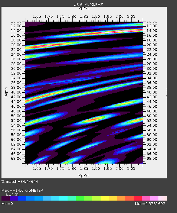
| Estimated Moho Depth: |
14.0 km |
| Estimated Crust Vp/Vs: |
2.01 |
| Assumed Crust Vp: |
6.483 km/s |
| Estimated Crust Vs: |
3.225 km/s |
| Estimated Crust Poisson's Ratio: |
0.34 |
|
| Radial Match: |
84.44644 % |
| Radial Bump: |
400 |
| Transverse Match: |
61.623905 % |
| Transverse Bump: |
400 |
| SOD ConfigId: |
26694651 |
| Insert Time: |
2021-11-23 03:14:46.726 +0000 |
| GWidth: |
2.5 |
| Max Bumps: |
400 |
| Tol: |
0.001 |
|

Signal To Noise
| Channel | StoN | STA | LTA |
| US:GLMI:00:BHZ:20211109T02:59:58.449014Z | 3.7404907 | 1.2899873E-6 | 3.4487113E-7 |
| US:GLMI:00:BH1:20211109T02:59:58.449014Z | 3.2192483 | 1.4378593E-6 | 4.466444E-7 |
| US:GLMI:00:BH2:20211109T02:59:58.449014Z | 1.1267662 | 4.831051E-7 | 4.2875362E-7 |
| Arrivals |
| Ps | 2.3 SECOND |
| PpPs | 6.1 SECOND |
| PsPs/PpSs | 8.4 SECOND |


