You are here: Home > Network List > IU - Global Seismograph Network (GSN - IRIS/USGS) Stations List
> Station PMG Port Moresby, New Guinea > Earthquake Result Viewer
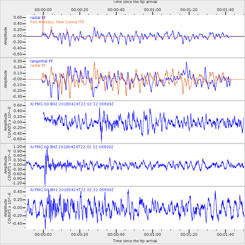
PMG Port Moresby, New Guinea - Earthquake Result Viewer
*The percent match for this event was below the threshold and hence no stack was calculated.
| Earthquake location: |
South Of Fiji Islands |
| Earthquake latitude/longitude: |
-23.9/179.8 |
| Earthquake time(UTC): |
2018/04/24 (114) 21:57:00 GMT |
| Earthquake Depth: |
530 km |
| Earthquake Magnitude: |
5.5 Mww |
| Earthquake Catalog/Contributor: |
NEIC PDE/us |
|
| Network: |
IU Global Seismograph Network (GSN - IRIS/USGS) |
| Station: |
PMG Port Moresby, New Guinea |
| Lat/Lon: |
9.40 S/147.16 E |
| Elevation: |
90 m |
|
| Distance: |
34.4 deg |
| Az: |
289.274 deg |
| Baz: |
118.901 deg |
| Ray Param: |
$rayparam |
*The percent match for this event was below the threshold and hence was not used in the summary stack. |
|
| Radial Match: |
49.096714 % |
| Radial Bump: |
400 |
| Transverse Match: |
52.187958 % |
| Transverse Bump: |
400 |
| SOD ConfigId: |
2665671 |
| Insert Time: |
2018-05-08 21:58:43.507 +0000 |
| GWidth: |
2.5 |
| Max Bumps: |
400 |
| Tol: |
0.001 |
|
Signal To Noise
| Channel | StoN | STA | LTA |
| IU:PMG:00:BHZ:20180424T22:02:32.06899Z | 4.065587 | 4.5475332E-7 | 1.11854284E-7 |
| IU:PMG:00:BH1:20180424T22:02:32.06899Z | 1.2839595 | 2.0967396E-7 | 1.6330263E-7 |
| IU:PMG:00:BH2:20180424T22:02:32.06899Z | 1.7983158 | 2.4842723E-7 | 1.3814437E-7 |
| Arrivals |
| Ps | |
| PpPs | |
| PsPs/PpSs | |


