You are here: Home > Network List > AK - Alaska Regional Network Stations List
> Station G24K Hadweenzic River, AK, USA > Earthquake Result Viewer
G24K Hadweenzic River, AK, USA - Earthquake Result Viewer
| Earthquake location: |
Near Coast Of Nicaragua |
| Earthquake latitude/longitude: |
11.2/-86.5 |
| Earthquake time(UTC): |
2021/11/09 (313) 06:25:17 GMT |
| Earthquake Depth: |
35 km |
| Earthquake Magnitude: |
6.2 mww |
| Earthquake Catalog/Contributor: |
NEIC PDE/us |
|
| Network: |
AK Alaska Regional Network |
| Station: |
G24K Hadweenzic River, AK, USA |
| Lat/Lon: |
66.70 N/147.48 W |
| Elevation: |
503 m |
|
| Distance: |
68.5 deg |
| Az: |
338.047 deg |
| Baz: |
112.769 deg |
| Ray Param: |
0.05623145 |
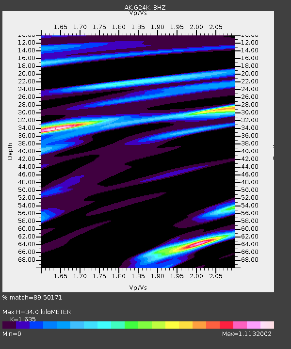
| Estimated Moho Depth: |
34.0 km |
| Estimated Crust Vp/Vs: |
1.63 |
| Assumed Crust Vp: |
6.522 km/s |
| Estimated Crust Vs: |
3.989 km/s |
| Estimated Crust Poisson's Ratio: |
0.20 |
|
| Radial Match: |
89.50171 % |
| Radial Bump: |
400 |
| Transverse Match: |
68.33735 % |
| Transverse Bump: |
400 |
| SOD ConfigId: |
26694651 |
| Insert Time: |
2021-11-23 06:40:24.017 +0000 |
| GWidth: |
2.5 |
| Max Bumps: |
400 |
| Tol: |
0.001 |
|

Signal To Noise
| Channel | StoN | STA | LTA |
| AK:G24K: :BHZ:20211109T06:35:44.779989Z | 8.54769 | 1.2553045E-6 | 1.4685891E-7 |
| AK:G24K: :BHN:20211109T06:35:44.779989Z | 2.7765703 | 2.837143E-7 | 1.0218156E-7 |
| AK:G24K: :BHE:20211109T06:35:44.779989Z | 3.8672388 | 5.1095884E-7 | 1.3212498E-7 |
| Arrivals |
| Ps | 3.5 SECOND |
| PpPs | 13 SECOND |
| PsPs/PpSs | 17 SECOND |


