You are here: Home > Network List > AK - Alaska Regional Network Stations List
> Station M20K Styx River, AK, USA > Earthquake Result Viewer
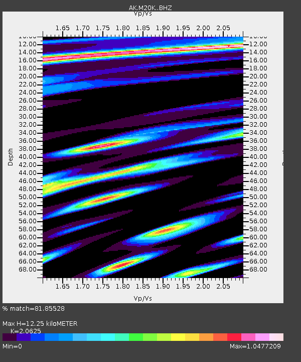
M20K Styx River, AK, USA - Earthquake Result Viewer
| Earthquake location: |
Near Coast Of Nicaragua |
| Earthquake latitude/longitude: |
11.2/-86.5 |
| Earthquake time(UTC): |
2021/11/09 (313) 06:25:17 GMT |
| Earthquake Depth: |
35 km |
| Earthquake Magnitude: |
6.2 mww |
| Earthquake Catalog/Contributor: |
NEIC PDE/us |
|
| Network: |
AK Alaska Regional Network |
| Station: |
M20K Styx River, AK, USA |
| Lat/Lon: |
61.88 N/153.13 W |
| Elevation: |
1107 m |
|
| Distance: |
69.2 deg |
| Az: |
332.283 deg |
| Baz: |
105.591 deg |
| Ray Param: |
0.055744667 |
| Estimated Moho Depth: |
12.25 km |
| Estimated Crust Vp/Vs: |
2.06 |
| Assumed Crust Vp: |
6.566 km/s |
| Estimated Crust Vs: |
3.184 km/s |
| Estimated Crust Poisson's Ratio: |
0.35 |
|
| Radial Match: |
81.85528 % |
| Radial Bump: |
400 |
| Transverse Match: |
60.772243 % |
| Transverse Bump: |
400 |
| SOD ConfigId: |
26694651 |
| Insert Time: |
2021-11-23 06:41:33.330 +0000 |
| GWidth: |
2.5 |
| Max Bumps: |
400 |
| Tol: |
0.001 |
|

Signal To Noise
| Channel | StoN | STA | LTA |
| AK:M20K: :BHZ:20211109T06:35:49.399984Z | 8.838063 | 1.0784562E-6 | 1.2202403E-7 |
| AK:M20K: :BHN:20211109T06:35:49.399984Z | 1.1177344 | 1.8192374E-7 | 1.6276115E-7 |
| AK:M20K: :BHE:20211109T06:35:49.399984Z | 3.4190416 | 3.476913E-7 | 1.0169263E-7 |
| Arrivals |
| Ps | 2.1 SECOND |
| PpPs | 5.5 SECOND |
| PsPs/PpSs | 7.6 SECOND |


