You are here: Home > Network List > TA - USArray Transportable Network (new EarthScope stations) Stations List
> Station TOLK Toolik Lake Research Station, AK, USA > Earthquake Result Viewer
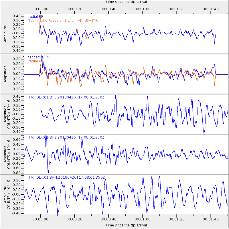
TOLK Toolik Lake Research Station, AK, USA - Earthquake Result Viewer
*The percent match for this event was below the threshold and hence no stack was calculated.
| Earthquake location: |
Near North Coast Of Irian Jaya |
| Earthquake latitude/longitude: |
-1.9/139.8 |
| Earthquake time(UTC): |
2018/04/26 (116) 16:55:58 GMT |
| Earthquake Depth: |
10 km |
| Earthquake Magnitude: |
5.6 Mww |
| Earthquake Catalog/Contributor: |
NEIC PDE/us |
|
| Network: |
TA USArray Transportable Network (new EarthScope stations) |
| Station: |
TOLK Toolik Lake Research Station, AK, USA |
| Lat/Lon: |
68.64 N/149.57 W |
| Elevation: |
760 m |
|
| Distance: |
84.8 deg |
| Az: |
20.308 deg |
| Baz: |
251.242 deg |
| Ray Param: |
$rayparam |
*The percent match for this event was below the threshold and hence was not used in the summary stack. |
|
| Radial Match: |
53.77913 % |
| Radial Bump: |
330 |
| Transverse Match: |
58.799194 % |
| Transverse Bump: |
399 |
| SOD ConfigId: |
2665671 |
| Insert Time: |
2018-05-10 16:58:29.832 +0000 |
| GWidth: |
2.5 |
| Max Bumps: |
400 |
| Tol: |
0.001 |
|
Signal To Noise
| Channel | StoN | STA | LTA |
| TA:TOLK:01:BHZ:20180426T17:08:01.350Z | 2.1646938 | 3.7921353E-7 | 1.7518114E-7 |
| TA:TOLK:01:BHN:20180426T17:08:01.350Z | 1.1514444 | 1.6155616E-7 | 1.4030738E-7 |
| TA:TOLK:01:BHE:20180426T17:08:01.350Z | 1.904515 | 1.9276885E-7 | 1.0121677E-7 |
| Arrivals |
| Ps | |
| PpPs | |
| PsPs/PpSs | |


