You are here: Home > Network List > AV - Alaska Volcano Observatory Stations List
> Station Q17K Contact Creek, Katmai, AK, USA > Earthquake Result Viewer
Q17K Contact Creek, Katmai, AK, USA - Earthquake Result Viewer
| Earthquake location: |
Near Coast Of Nicaragua |
| Earthquake latitude/longitude: |
11.2/-86.5 |
| Earthquake time(UTC): |
2021/11/09 (313) 06:25:17 GMT |
| Earthquake Depth: |
35 km |
| Earthquake Magnitude: |
6.2 mww |
| Earthquake Catalog/Contributor: |
NEIC PDE/us |
|
| Network: |
AV Alaska Volcano Observatory |
| Station: |
Q17K Contact Creek, Katmai, AK, USA |
| Lat/Lon: |
58.26 N/155.89 W |
| Elevation: |
1165 m |
|
| Distance: |
69.7 deg |
| Az: |
328.167 deg |
| Baz: |
101.762 deg |
| Ray Param: |
0.055420954 |
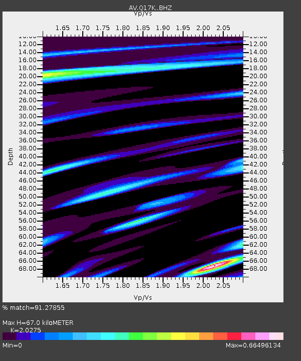
| Estimated Moho Depth: |
67.0 km |
| Estimated Crust Vp/Vs: |
2.03 |
| Assumed Crust Vp: |
6.438 km/s |
| Estimated Crust Vs: |
3.175 km/s |
| Estimated Crust Poisson's Ratio: |
0.34 |
|
| Radial Match: |
91.27855 % |
| Radial Bump: |
381 |
| Transverse Match: |
70.40378 % |
| Transverse Bump: |
400 |
| SOD ConfigId: |
26694651 |
| Insert Time: |
2021-11-23 06:45:17.983 +0000 |
| GWidth: |
2.5 |
| Max Bumps: |
400 |
| Tol: |
0.001 |
|

Signal To Noise
| Channel | StoN | STA | LTA |
| AV:Q17K: :BHZ:20211109T06:35:52.375021Z | 7.070309 | 1.1560832E-6 | 1.635124E-7 |
| AV:Q17K: :BHN:20211109T06:35:52.375021Z | 1.1009629 | 1.9072746E-7 | 1.7323697E-7 |
| AV:Q17K: :BHE:20211109T06:35:52.375021Z | 6.0994396 | 8.8284224E-7 | 1.4474153E-7 |
| Arrivals |
| Ps | 11 SECOND |
| PpPs | 30 SECOND |
| PsPs/PpSs | 42 SECOND |


