You are here: Home > Network List > AV - Alaska Volcano Observatory Stations List
> Station SPWE Spurr West, Mount Spurr, Alaska > Earthquake Result Viewer
SPWE Spurr West, Mount Spurr, Alaska - Earthquake Result Viewer
| Earthquake location: |
Near Coast Of Nicaragua |
| Earthquake latitude/longitude: |
11.2/-86.5 |
| Earthquake time(UTC): |
2021/11/09 (313) 06:25:17 GMT |
| Earthquake Depth: |
35 km |
| Earthquake Magnitude: |
6.2 mww |
| Earthquake Catalog/Contributor: |
NEIC PDE/us |
|
| Network: |
AV Alaska Volcano Observatory |
| Station: |
SPWE Spurr West, Mount Spurr, Alaska |
| Lat/Lon: |
61.27 N/152.56 W |
| Elevation: |
1317 m |
|
| Distance: |
68.8 deg |
| Az: |
331.732 deg |
| Baz: |
105.897 deg |
| Ray Param: |
0.056029953 |
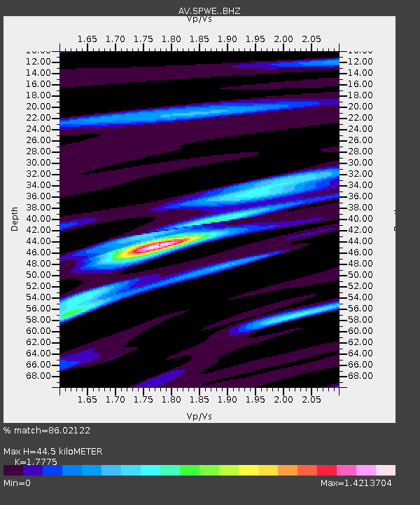
| Estimated Moho Depth: |
44.5 km |
| Estimated Crust Vp/Vs: |
1.78 |
| Assumed Crust Vp: |
6.566 km/s |
| Estimated Crust Vs: |
3.694 km/s |
| Estimated Crust Poisson's Ratio: |
0.27 |
|
| Radial Match: |
86.02122 % |
| Radial Bump: |
400 |
| Transverse Match: |
77.33186 % |
| Transverse Bump: |
400 |
| SOD ConfigId: |
26694651 |
| Insert Time: |
2021-11-23 06:45:40.627 +0000 |
| GWidth: |
2.5 |
| Max Bumps: |
400 |
| Tol: |
0.001 |
|

Signal To Noise
| Channel | StoN | STA | LTA |
| AV:SPWE: :BHZ:20211109T06:35:46.740011Z | 7.331118 | 6.83664E-7 | 9.3255075E-8 |
| AV:SPWE: :BHN:20211109T06:35:46.740011Z | 2.4054337 | 2.0740418E-7 | 8.62232E-8 |
| AV:SPWE: :BHE:20211109T06:35:46.740011Z | 2.7108307 | 2.8871636E-7 | 1.0650476E-7 |
| Arrivals |
| Ps | 5.5 SECOND |
| PpPs | 18 SECOND |
| PsPs/PpSs | 24 SECOND |


