You are here: Home > Network List > CI - Caltech Regional Seismic Network Stations List
> Station MPP McPhearson Peak > Earthquake Result Viewer
MPP McPhearson Peak - Earthquake Result Viewer
| Earthquake location: |
Near Coast Of Nicaragua |
| Earthquake latitude/longitude: |
11.2/-86.5 |
| Earthquake time(UTC): |
2021/11/09 (313) 06:25:17 GMT |
| Earthquake Depth: |
35 km |
| Earthquake Magnitude: |
6.2 mww |
| Earthquake Catalog/Contributor: |
NEIC PDE/us |
|
| Network: |
CI Caltech Regional Seismic Network |
| Station: |
MPP McPhearson Peak |
| Lat/Lon: |
34.89 N/119.81 W |
| Elevation: |
1739 m |
|
| Distance: |
38.3 deg |
| Az: |
313.327 deg |
| Baz: |
119.752 deg |
| Ray Param: |
0.07557501 |
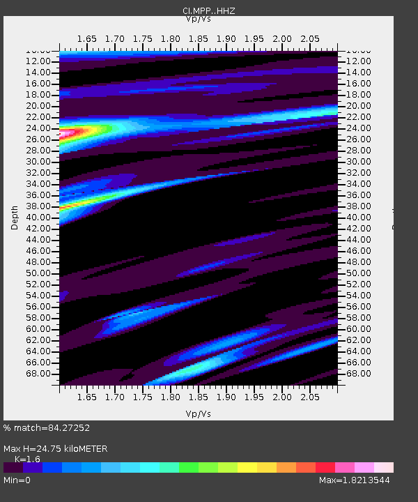
| Estimated Moho Depth: |
24.75 km |
| Estimated Crust Vp/Vs: |
1.60 |
| Assumed Crust Vp: |
6.1 km/s |
| Estimated Crust Vs: |
3.812 km/s |
| Estimated Crust Poisson's Ratio: |
0.18 |
|
| Radial Match: |
84.27252 % |
| Radial Bump: |
400 |
| Transverse Match: |
71.101974 % |
| Transverse Bump: |
400 |
| SOD ConfigId: |
26694651 |
| Insert Time: |
2021-11-23 06:49:52.097 +0000 |
| GWidth: |
2.5 |
| Max Bumps: |
400 |
| Tol: |
0.001 |
|
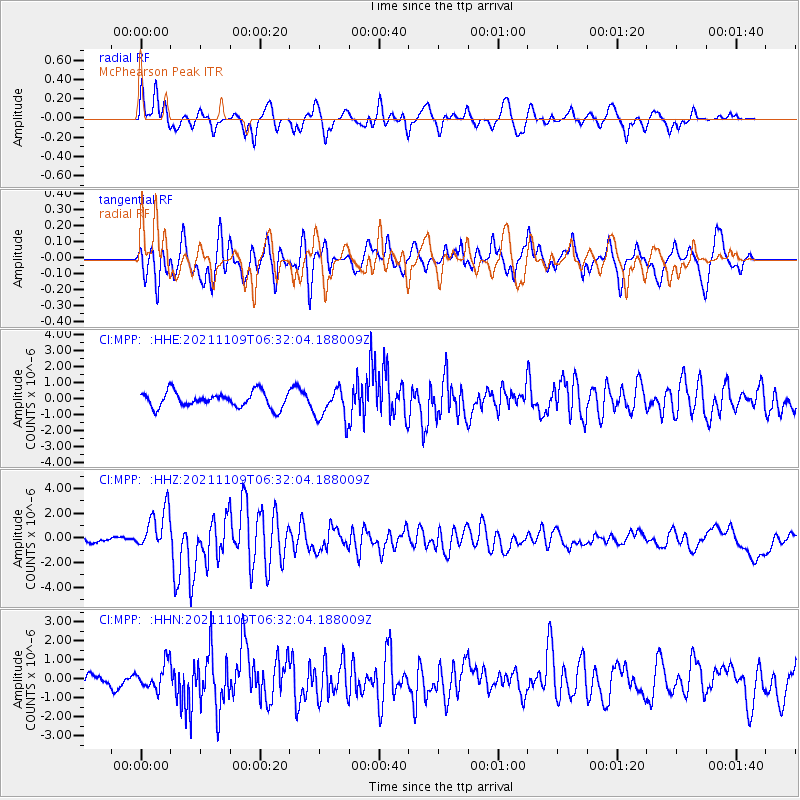
Signal To Noise
| Channel | StoN | STA | LTA |
| CI:MPP: :HHZ:20211109T06:32:04.188009Z | 4.988079 | 1.706481E-6 | 3.4211186E-7 |
| CI:MPP: :HHN:20211109T06:32:04.188009Z | 2.0168335 | 6.617862E-7 | 3.281313E-7 |
| CI:MPP: :HHE:20211109T06:32:04.188009Z | 2.1419008 | 1.0391535E-6 | 4.851548E-7 |
| Arrivals |
| Ps | 2.6 SECOND |
| PpPs | 9.8 SECOND |
| PsPs/PpSs | 12 SECOND |


