You are here: Home > Network List > US - United States National Seismic Network Stations List
> Station EGMT Eagleton, Montana, USA > Earthquake Result Viewer
EGMT Eagleton, Montana, USA - Earthquake Result Viewer
*The percent match for this event was below the threshold and hence no stack was calculated.
| Earthquake location: |
Afghanistan-Tajikistan Bord Reg. |
| Earthquake latitude/longitude: |
36.3/71.2 |
| Earthquake time(UTC): |
2018/04/28 (118) 15:14:20 GMT |
| Earthquake Depth: |
91 km |
| Earthquake Magnitude: |
5.2 Mww |
| Earthquake Catalog/Contributor: |
NEIC PDE/us |
|
| Network: |
US United States National Seismic Network |
| Station: |
EGMT Eagleton, Montana, USA |
| Lat/Lon: |
48.02 N/109.75 W |
| Elevation: |
1055 m |
|
| Distance: |
96.0 deg |
| Az: |
0.611 deg |
| Baz: |
359.265 deg |
| Ray Param: |
$rayparam |
*The percent match for this event was below the threshold and hence was not used in the summary stack. |
|
| Radial Match: |
32.416813 % |
| Radial Bump: |
400 |
| Transverse Match: |
44.652126 % |
| Transverse Bump: |
400 |
| SOD ConfigId: |
2665671 |
| Insert Time: |
2018-05-12 15:17:00.795 +0000 |
| GWidth: |
2.5 |
| Max Bumps: |
400 |
| Tol: |
0.001 |
|
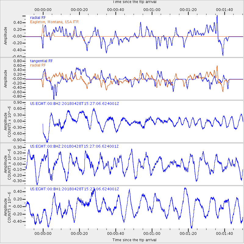
Signal To Noise
| Channel | StoN | STA | LTA |
| US:EGMT:00:BHZ:20180428T15:27:06.624001Z | 0.9017556 | 1.5439221E-7 | 1.7121293E-7 |
| US:EGMT:00:BH1:20180428T15:27:06.624001Z | 1.7089245 | 3.8885048E-7 | 2.2754105E-7 |
| US:EGMT:00:BH2:20180428T15:27:06.624001Z | 0.7198205 | 2.7641664E-7 | 3.8400776E-7 |
| Arrivals |
| Ps | |
| PpPs | |
| PsPs/PpSs | |


