You are here: Home > Network List > US - United States National Seismic Network Stations List
> Station MSO Missoula, Montana, USA > Earthquake Result Viewer
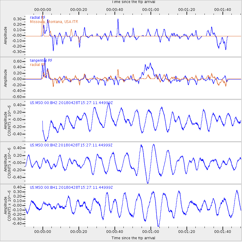
MSO Missoula, Montana, USA - Earthquake Result Viewer
*The percent match for this event was below the threshold and hence no stack was calculated.
| Earthquake location: |
Afghanistan-Tajikistan Bord Reg. |
| Earthquake latitude/longitude: |
36.3/71.2 |
| Earthquake time(UTC): |
2018/04/28 (118) 15:14:20 GMT |
| Earthquake Depth: |
91 km |
| Earthquake Magnitude: |
5.2 Mww |
| Earthquake Catalog/Contributor: |
NEIC PDE/us |
|
| Network: |
US United States National Seismic Network |
| Station: |
MSO Missoula, Montana, USA |
| Lat/Lon: |
46.83 N/113.94 W |
| Elevation: |
1264 m |
|
| Distance: |
97.1 deg |
| Az: |
3.52 deg |
| Baz: |
355.859 deg |
| Ray Param: |
$rayparam |
*The percent match for this event was below the threshold and hence was not used in the summary stack. |
|
| Radial Match: |
68.82 % |
| Radial Bump: |
400 |
| Transverse Match: |
47.20517 % |
| Transverse Bump: |
400 |
| SOD ConfigId: |
2665671 |
| Insert Time: |
2018-05-12 15:17:07.378 +0000 |
| GWidth: |
2.5 |
| Max Bumps: |
400 |
| Tol: |
0.001 |
|
Signal To Noise
| Channel | StoN | STA | LTA |
| US:MSO:00:BHZ:20180428T15:27:11.44999Z | 0.9164831 | 8.841438E-8 | 9.647137E-8 |
| US:MSO:00:BH1:20180428T15:27:11.44999Z | 0.5330595 | 5.8858127E-8 | 1.10415684E-7 |
| US:MSO:00:BH2:20180428T15:27:11.44999Z | 1.0948447 | 2.1307486E-7 | 1.946165E-7 |
| Arrivals |
| Ps | |
| PpPs | |
| PsPs/PpSs | |


