You are here: Home > Network List > CN - Canadian National Seismograph Network Stations List
> Station INK INUVIK, NT > Earthquake Result Viewer
INK INUVIK, NT - Earthquake Result Viewer
*The percent match for this event was below the threshold and hence no stack was calculated.
| Earthquake location: |
Near Coast Of Nicaragua |
| Earthquake latitude/longitude: |
11.2/-86.5 |
| Earthquake time(UTC): |
2021/11/09 (313) 06:25:17 GMT |
| Earthquake Depth: |
35 km |
| Earthquake Magnitude: |
6.2 mww |
| Earthquake Catalog/Contributor: |
NEIC PDE/us |
|
| Network: |
CN Canadian National Seismograph Network |
| Station: |
INK INUVIK, NT |
| Lat/Lon: |
68.31 N/133.53 W |
| Elevation: |
44 m |
|
| Distance: |
64.6 deg |
| Az: |
342.485 deg |
| Baz: |
127.423 deg |
| Ray Param: |
$rayparam |
*The percent match for this event was below the threshold and hence was not used in the summary stack. |
|
| Radial Match: |
77.0321 % |
| Radial Bump: |
386 |
| Transverse Match: |
64.424126 % |
| Transverse Bump: |
400 |
| SOD ConfigId: |
26694651 |
| Insert Time: |
2021-11-23 06:51:34.445 +0000 |
| GWidth: |
2.5 |
| Max Bumps: |
400 |
| Tol: |
0.001 |
|
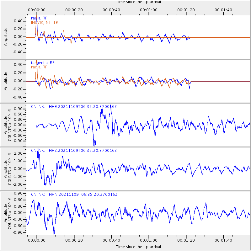
Signal To Noise
| Channel | StoN | STA | LTA |
| CN:INK: :HHZ:20211109T06:35:20.370016Z | 6.3806486 | 1.2399823E-6 | 1.9433485E-7 |
| CN:INK: :HHN:20211109T06:35:20.370016Z | 1.278806 | 2.7335108E-7 | 2.1375492E-7 |
| CN:INK: :HHE:20211109T06:35:20.370016Z | 2.8653457 | 5.689103E-7 | 1.9854858E-7 |
| Arrivals |
| Ps | |
| PpPs | |
| PsPs/PpSs | |


