You are here: Home > Network List > II - Global Seismograph Network (GSN - IRIS/IDA) Stations List
> Station XPFO Pinon Flat, California, USA > Earthquake Result Viewer
XPFO Pinon Flat, California, USA - Earthquake Result Viewer
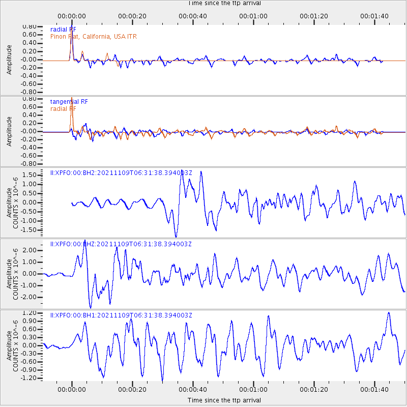
| Earthquake location: |
Near Coast Of Nicaragua |
| Earthquake latitude/longitude: |
11.2/-86.5 |
| Earthquake time(UTC): |
2021/11/09 (313) 06:25:17 GMT |
| Earthquake Depth: |
35 km |
| Earthquake Magnitude: |
6.2 mww |
| Earthquake Catalog/Contributor: |
NEIC PDE/us |
|
| Network: |
II Global Seismograph Network (GSN - IRIS/IDA) |
| Station: |
XPFO Pinon Flat, California, USA |
| Lat/Lon: |
33.61 N/116.46 W |
| Elevation: |
1280 m |
|
| Distance: |
35.3 deg |
| Az: |
313.888 deg |
| Baz: |
122.083 deg |
| Ray Param: |
0.07723188 |
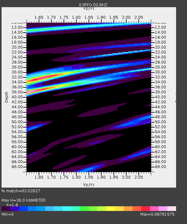
| Estimated Moho Depth: |
38.0 km |
| Estimated Crust Vp/Vs: |
1.60 |
| Assumed Crust Vp: |
6.264 km/s |
| Estimated Crust Vs: |
3.915 km/s |
| Estimated Crust Poisson's Ratio: |
0.18 |
|
| Radial Match: |
83.02827 % |
| Radial Bump: |
320 |
| Transverse Match: |
67.89503 % |
| Transverse Bump: |
400 |
| SOD ConfigId: |
26694651 |
| Insert Time: |
2021-11-23 06:54:15.121 +0000 |
| GWidth: |
2.5 |
| Max Bumps: |
400 |
| Tol: |
0.001 |
|
Signal To Noise
| Channel | StoN | STA | LTA |
| II:XPFO:00:BHZ:20211109T06:31:38.394003Z | 7.177311 | 1.3606347E-6 | 1.8957444E-7 |
| II:XPFO:00:BH1:20211109T06:31:38.394003Z | 3.3138664 | 4.4116433E-7 | 1.3312678E-7 |
| II:XPFO:00:BH2:20211109T06:31:38.394003Z | 6.1049657 | 8.873163E-7 | 1.4534336E-7 |
| Arrivals |
| Ps | 3.9 SECOND |
| PpPs | 15 SECOND |
| PsPs/PpSs | 19 SECOND |


