You are here: Home > Network List > N4 - Central and EAstern US Network Stations List
> Station K22A Casper, WY, USA > Earthquake Result Viewer
K22A Casper, WY, USA - Earthquake Result Viewer
| Earthquake location: |
Near Coast Of Nicaragua |
| Earthquake latitude/longitude: |
11.2/-86.5 |
| Earthquake time(UTC): |
2021/11/09 (313) 06:25:17 GMT |
| Earthquake Depth: |
35 km |
| Earthquake Magnitude: |
6.2 mww |
| Earthquake Catalog/Contributor: |
NEIC PDE/us |
|
| Network: |
N4 Central and EAstern US Network |
| Station: |
K22A Casper, WY, USA |
| Lat/Lon: |
42.65 N/106.52 W |
| Elevation: |
1686 m |
|
| Distance: |
35.8 deg |
| Az: |
334.457 deg |
| Baz: |
145.012 deg |
| Ray Param: |
0.07696494 |
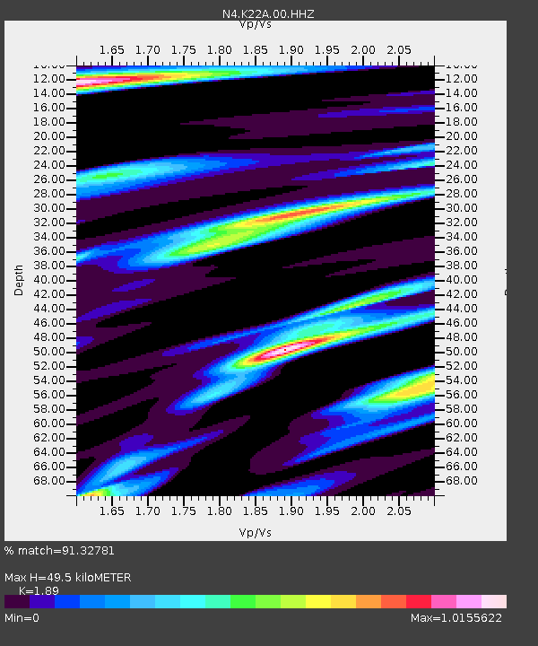
| Estimated Moho Depth: |
49.5 km |
| Estimated Crust Vp/Vs: |
1.89 |
| Assumed Crust Vp: |
6.178 km/s |
| Estimated Crust Vs: |
3.269 km/s |
| Estimated Crust Poisson's Ratio: |
0.31 |
|
| Radial Match: |
91.32781 % |
| Radial Bump: |
305 |
| Transverse Match: |
72.81461 % |
| Transverse Bump: |
400 |
| SOD ConfigId: |
26694651 |
| Insert Time: |
2021-11-23 06:56:11.153 +0000 |
| GWidth: |
2.5 |
| Max Bumps: |
400 |
| Tol: |
0.001 |
|

Signal To Noise
| Channel | StoN | STA | LTA |
| N4:K22A:00:HHZ:20211109T06:31:42.899008Z | 12.425878 | 1.4849644E-6 | 1.195058E-7 |
| N4:K22A:00:HH1:20211109T06:31:42.899008Z | 4.5205274 | 8.8137534E-7 | 1.9497179E-7 |
| N4:K22A:00:HH2:20211109T06:31:42.899008Z | 1.7928823 | 5.272306E-7 | 2.940687E-7 |
| Arrivals |
| Ps | 7.6 SECOND |
| PpPs | 22 SECOND |
| PsPs/PpSs | 29 SECOND |


