You are here: Home > Network List > N4 - Central and EAstern US Network Stations List
> Station SUSD Miller, SD, USA > Earthquake Result Viewer
SUSD Miller, SD, USA - Earthquake Result Viewer
| Earthquake location: |
Near Coast Of Nicaragua |
| Earthquake latitude/longitude: |
11.2/-86.5 |
| Earthquake time(UTC): |
2021/11/09 (313) 06:25:17 GMT |
| Earthquake Depth: |
35 km |
| Earthquake Magnitude: |
6.2 mww |
| Earthquake Catalog/Contributor: |
NEIC PDE/us |
|
| Network: |
N4 Central and EAstern US Network |
| Station: |
SUSD Miller, SD, USA |
| Lat/Lon: |
44.44 N/98.96 W |
| Elevation: |
520 m |
|
| Distance: |
34.8 deg |
| Az: |
344.311 deg |
| Baz: |
158.261 deg |
| Ray Param: |
0.077506036 |
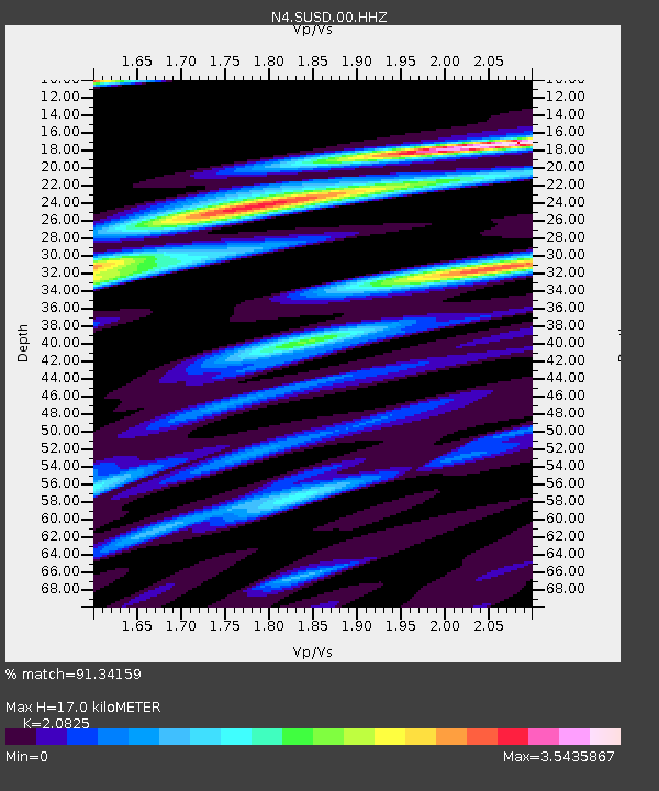
| Estimated Moho Depth: |
17.0 km |
| Estimated Crust Vp/Vs: |
2.08 |
| Assumed Crust Vp: |
6.53 km/s |
| Estimated Crust Vs: |
3.136 km/s |
| Estimated Crust Poisson's Ratio: |
0.35 |
|
| Radial Match: |
91.34159 % |
| Radial Bump: |
361 |
| Transverse Match: |
65.50153 % |
| Transverse Bump: |
400 |
| SOD ConfigId: |
26694651 |
| Insert Time: |
2021-11-23 06:56:32.970 +0000 |
| GWidth: |
2.5 |
| Max Bumps: |
400 |
| Tol: |
0.001 |
|

Signal To Noise
| Channel | StoN | STA | LTA |
| N4:SUSD:00:HHZ:20211109T06:31:33.950003Z | 14.04943 | 3.0148544E-6 | 2.145891E-7 |
| N4:SUSD:00:HH1:20211109T06:31:33.950003Z | 15.600541 | 4.1290414E-6 | 2.6467296E-7 |
| N4:SUSD:00:HH2:20211109T06:31:33.950003Z | 5.8343644 | 1.7519401E-6 | 3.0027954E-7 |
| Arrivals |
| Ps | 3.0 SECOND |
| PpPs | 7.5 SECOND |
| PsPs/PpSs | 11 SECOND |


