You are here: Home > Network List > TA - USArray Transportable Network (new EarthScope stations) Stations List
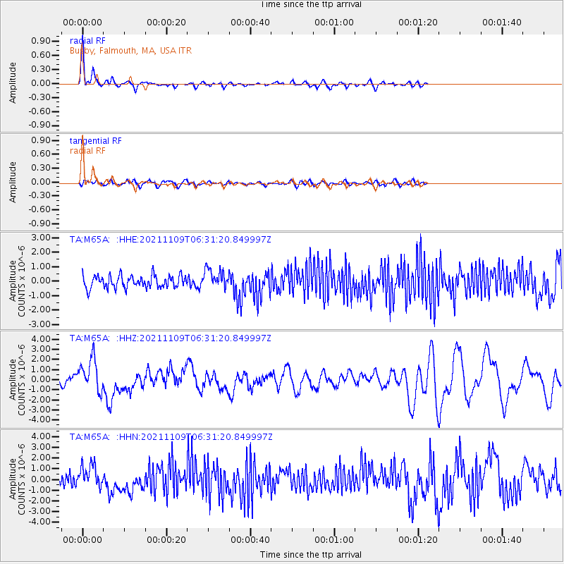
> Station M65A Busby, Falmouth, MA, USA > Earthquake Result Viewer
M65A Busby, Falmouth, MA, USA - Earthquake Result Viewer
| Earthquake location: |
Near Coast Of Nicaragua |
| Earthquake latitude/longitude: |
11.2/-86.5 |
| Earthquake time(UTC): |
2021/11/09 (313) 06:25:17 GMT |
| Earthquake Depth: |
35 km |
| Earthquake Magnitude: |
6.2 mww |
| Earthquake Catalog/Contributor: |
NEIC PDE/us |
|
| Network: |
TA USArray Transportable Network (new EarthScope stations) |
| Station: |
M65A Busby, Falmouth, MA, USA |
| Lat/Lon: |
41.56 N/70.65 W |
| Elevation: |
22 m |
|
| Distance: |
33.3 deg |
| Az: |
21.97 deg |
| Baz: |
209.282 deg |
| Ray Param: |
0.078241326 |
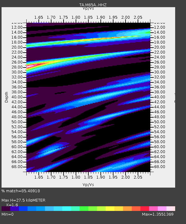
| Estimated Moho Depth: |
27.5 km |
| Estimated Crust Vp/Vs: |
1.60 |
| Assumed Crust Vp: |
6.472 km/s |
| Estimated Crust Vs: |
4.045 km/s |
| Estimated Crust Poisson's Ratio: |
0.18 |
|
| Radial Match: |
85.48918 % |
| Radial Bump: |
314 |
| Transverse Match: |
53.874794 % |
| Transverse Bump: |
400 |
| SOD ConfigId: |
26694651 |
| Insert Time: |
2021-11-23 07:00:15.292 +0000 |
| GWidth: |
2.5 |
| Max Bumps: |
400 |
| Tol: |
0.001 |
|
Signal To Noise
| Channel | StoN | STA | LTA |
| TA:M65A: :HHZ:20211109T06:31:20.849997Z | 3.2643375 | 1.6634136E-6 | 5.095716E-7 |
| TA:M65A: :HHN:20211109T06:31:20.849997Z | 2.4552674 | 1.0850628E-6 | 4.4193263E-7 |
| TA:M65A: :HHE:20211109T06:31:20.849997Z | 1.586057 | 6.650713E-7 | 4.1932373E-7 |
| Arrivals |
| Ps | 2.8 SECOND |
| PpPs | 10 SECOND |
| PsPs/PpSs | 13 SECOND |


