You are here: Home > Network List > UU - University of Utah Regional Network Stations List
> Station MOUT Mount Ogden, UT, USA > Earthquake Result Viewer
MOUT Mount Ogden, UT, USA - Earthquake Result Viewer
| Earthquake location: |
Near Coast Of Nicaragua |
| Earthquake latitude/longitude: |
11.2/-86.5 |
| Earthquake time(UTC): |
2021/11/09 (313) 06:25:17 GMT |
| Earthquake Depth: |
35 km |
| Earthquake Magnitude: |
6.2 mww |
| Earthquake Catalog/Contributor: |
NEIC PDE/us |
|
| Network: |
UU University of Utah Regional Network |
| Station: |
MOUT Mount Ogden, UT, USA |
| Lat/Lon: |
41.20 N/111.88 W |
| Elevation: |
2748 m |
|
| Distance: |
37.3 deg |
| Az: |
327.727 deg |
| Baz: |
136.035 deg |
| Ray Param: |
0.07618145 |
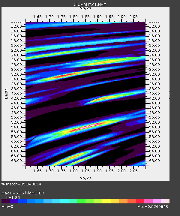
| Estimated Moho Depth: |
53.5 km |
| Estimated Crust Vp/Vs: |
1.86 |
| Assumed Crust Vp: |
6.155 km/s |
| Estimated Crust Vs: |
3.309 km/s |
| Estimated Crust Poisson's Ratio: |
0.30 |
|
| Radial Match: |
85.848854 % |
| Radial Bump: |
318 |
| Transverse Match: |
61.717083 % |
| Transverse Bump: |
400 |
| SOD ConfigId: |
26694651 |
| Insert Time: |
2021-11-23 07:02:04.400 +0000 |
| GWidth: |
2.5 |
| Max Bumps: |
400 |
| Tol: |
0.001 |
|

Signal To Noise
| Channel | StoN | STA | LTA |
| UU:MOUT:01:HHZ:20211109T06:31:55.010Z | 9.488835 | 1.748865E-6 | 1.8430765E-7 |
| UU:MOUT:01:HHN:20211109T06:31:55.010Z | 3.8919227 | 6.827113E-7 | 1.7541748E-7 |
| UU:MOUT:01:HHE:20211109T06:31:55.010Z | 1.503625 | 5.9554026E-7 | 3.9606965E-7 |
| Arrivals |
| Ps | 8.0 SECOND |
| PpPs | 23 SECOND |
| PsPs/PpSs | 31 SECOND |


