You are here: Home > Network List > IW - Intermountain West Stations List
> Station MOOW Moose Ponds, Wyoming, USA > Earthquake Result Viewer
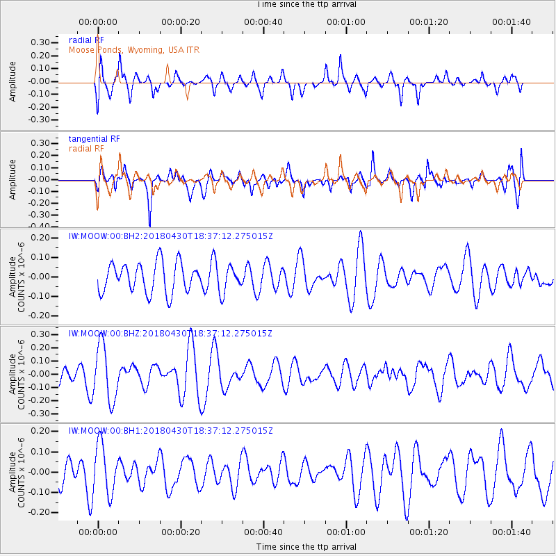
MOOW Moose Ponds, Wyoming, USA - Earthquake Result Viewer
*The percent match for this event was below the threshold and hence no stack was calculated.
| Earthquake location: |
Vanuatu Islands |
| Earthquake latitude/longitude: |
-16.0/168.3 |
| Earthquake time(UTC): |
2018/04/30 (120) 18:24:54 GMT |
| Earthquake Depth: |
269 km |
| Earthquake Magnitude: |
5.8 Mww |
| Earthquake Catalog/Contributor: |
NEIC PDE/us |
|
| Network: |
IW Intermountain West |
| Station: |
MOOW Moose Ponds, Wyoming, USA |
| Lat/Lon: |
43.75 N/110.74 W |
| Elevation: |
2128 m |
|
| Distance: |
94.5 deg |
| Az: |
45.876 deg |
| Baz: |
252.335 deg |
| Ray Param: |
$rayparam |
*The percent match for this event was below the threshold and hence was not used in the summary stack. |
|
| Radial Match: |
61.552856 % |
| Radial Bump: |
400 |
| Transverse Match: |
42.499268 % |
| Transverse Bump: |
400 |
| SOD ConfigId: |
2665671 |
| Insert Time: |
2018-05-14 18:31:11.412 +0000 |
| GWidth: |
2.5 |
| Max Bumps: |
400 |
| Tol: |
0.001 |
|
Signal To Noise
| Channel | StoN | STA | LTA |
| IW:MOOW:00:BHZ:20180430T18:37:12.275015Z | 3.32849 | 2.1253899E-7 | 6.385448E-8 |
| IW:MOOW:00:BH1:20180430T18:37:12.275015Z | 1.8031625 | 1.2199013E-7 | 6.765343E-8 |
| IW:MOOW:00:BH2:20180430T18:37:12.275015Z | 0.8591481 | 6.557131E-8 | 7.632131E-8 |
| Arrivals |
| Ps | |
| PpPs | |
| PsPs/PpSs | |


