You are here: Home > Network List > AK - Alaska Regional Network Stations List
> Station A19K Wainwright, AK, USA > Earthquake Result Viewer
A19K Wainwright, AK, USA - Earthquake Result Viewer
| Earthquake location: |
Southeast Of Ryukyu Islands |
| Earthquake latitude/longitude: |
23.5/126.5 |
| Earthquake time(UTC): |
2021/11/10 (314) 15:45:13 GMT |
| Earthquake Depth: |
10 km |
| Earthquake Magnitude: |
6.6 Mww |
| Earthquake Catalog/Contributor: |
NEIC PDE/us |
|
| Network: |
AK Alaska Regional Network |
| Station: |
A19K Wainwright, AK, USA |
| Lat/Lon: |
70.20 N/161.07 W |
| Elevation: |
24 m |
|
| Distance: |
62.1 deg |
| Az: |
21.561 deg |
| Baz: |
261.877 deg |
| Ray Param: |
0.060443643 |
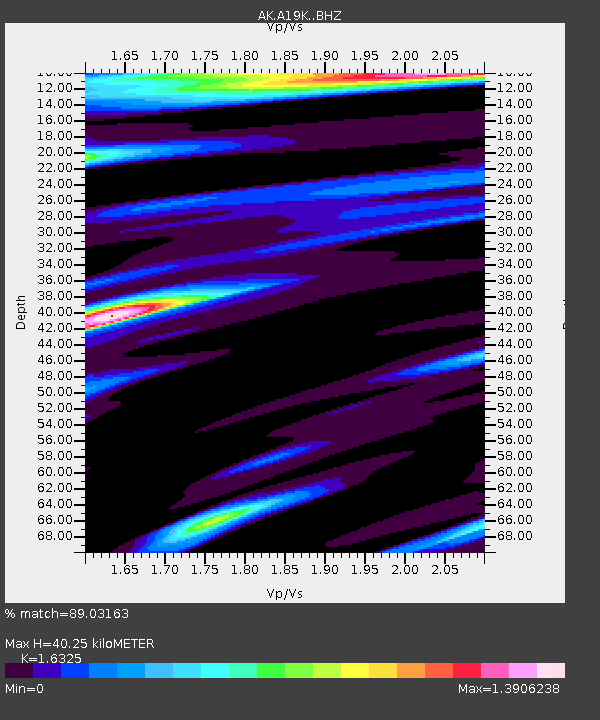
| Estimated Moho Depth: |
40.25 km |
| Estimated Crust Vp/Vs: |
1.63 |
| Assumed Crust Vp: |
5.989 km/s |
| Estimated Crust Vs: |
3.669 km/s |
| Estimated Crust Poisson's Ratio: |
0.20 |
|
| Radial Match: |
89.03163 % |
| Radial Bump: |
400 |
| Transverse Match: |
83.95605 % |
| Transverse Bump: |
400 |
| SOD ConfigId: |
26694651 |
| Insert Time: |
2021-11-24 15:46:17.288 +0000 |
| GWidth: |
2.5 |
| Max Bumps: |
400 |
| Tol: |
0.001 |
|

Signal To Noise
| Channel | StoN | STA | LTA |
| AK:A19K: :BHZ:20211110T15:55:02.879991Z | 1.9211236 | 7.3480436E-7 | 3.8248677E-7 |
| AK:A19K: :BHN:20211110T15:55:02.879991Z | 1.0583133 | 2.2476338E-7 | 2.1237888E-7 |
| AK:A19K: :BHE:20211110T15:55:02.879991Z | 1.4193066 | 4.1150116E-7 | 2.899311E-7 |
| Arrivals |
| Ps | 4.4 SECOND |
| PpPs | 17 SECOND |
| PsPs/PpSs | 21 SECOND |


