You are here: Home > Network List > AK - Alaska Regional Network Stations List
> Station ANM Anvil Mountian > Earthquake Result Viewer
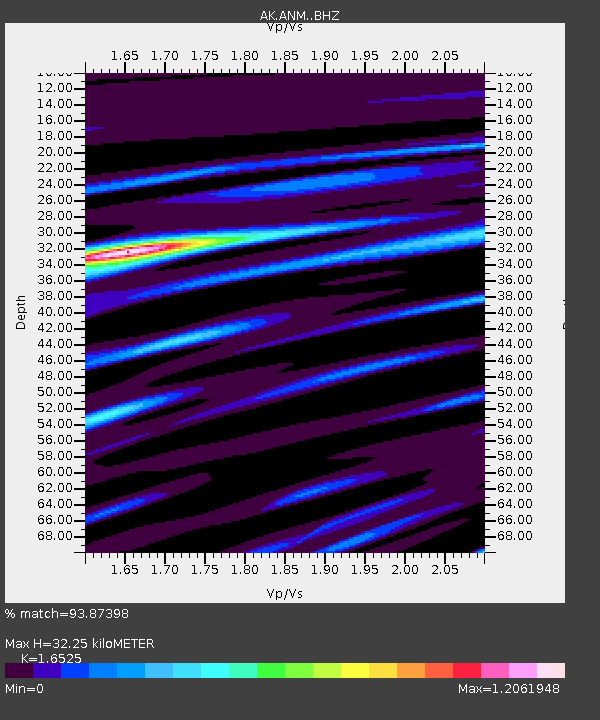
ANM Anvil Mountian - Earthquake Result Viewer
| Earthquake location: |
Southeast Of Ryukyu Islands |
| Earthquake latitude/longitude: |
23.5/126.5 |
| Earthquake time(UTC): |
2021/11/10 (314) 15:45:13 GMT |
| Earthquake Depth: |
10 km |
| Earthquake Magnitude: |
6.6 Mww |
| Earthquake Catalog/Contributor: |
NEIC PDE/us |
|
| Network: |
AK Alaska Regional Network |
| Station: |
ANM Anvil Mountian |
| Lat/Lon: |
64.56 N/165.37 W |
| Elevation: |
330 m |
|
| Distance: |
59.6 deg |
| Az: |
27.691 deg |
| Baz: |
260.895 deg |
| Ray Param: |
0.062068798 |
| Estimated Moho Depth: |
32.25 km |
| Estimated Crust Vp/Vs: |
1.65 |
| Assumed Crust Vp: |
6.276 km/s |
| Estimated Crust Vs: |
3.798 km/s |
| Estimated Crust Poisson's Ratio: |
0.21 |
|
| Radial Match: |
93.87398 % |
| Radial Bump: |
400 |
| Transverse Match: |
82.45541 % |
| Transverse Bump: |
400 |
| SOD ConfigId: |
26694651 |
| Insert Time: |
2021-11-24 15:46:20.730 +0000 |
| GWidth: |
2.5 |
| Max Bumps: |
400 |
| Tol: |
0.001 |
|

Signal To Noise
| Channel | StoN | STA | LTA |
| AK:ANM: :BHZ:20211110T15:54:45.947984Z | 3.1354742 | 6.4986455E-7 | 2.0726196E-7 |
| AK:ANM: :BHN:20211110T15:54:45.947984Z | 0.83607537 | 1.7584051E-7 | 2.1031659E-7 |
| AK:ANM: :BHE:20211110T15:54:45.947984Z | 1.6925273 | 3.6724037E-7 | 2.1697753E-7 |
| Arrivals |
| Ps | 3.5 SECOND |
| PpPs | 13 SECOND |
| PsPs/PpSs | 17 SECOND |


