You are here: Home > Network List > AK - Alaska Regional Network Stations List
> Station B22K Teshekpuk Lake, AK, USA > Earthquake Result Viewer
B22K Teshekpuk Lake, AK, USA - Earthquake Result Viewer
| Earthquake location: |
Southeast Of Ryukyu Islands |
| Earthquake latitude/longitude: |
23.5/126.5 |
| Earthquake time(UTC): |
2021/11/10 (314) 15:45:13 GMT |
| Earthquake Depth: |
10 km |
| Earthquake Magnitude: |
6.6 Mww |
| Earthquake Catalog/Contributor: |
NEIC PDE/us |
|
| Network: |
AK Alaska Regional Network |
| Station: |
B22K Teshekpuk Lake, AK, USA |
| Lat/Lon: |
70.34 N/153.42 W |
| Elevation: |
50 m |
|
| Distance: |
64.7 deg |
| Az: |
21.638 deg |
| Baz: |
269.11 deg |
| Ray Param: |
0.058747374 |
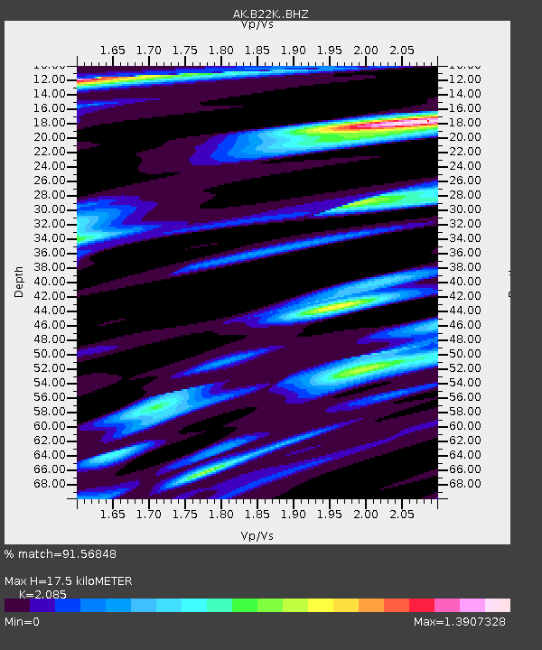
| Estimated Moho Depth: |
17.5 km |
| Estimated Crust Vp/Vs: |
2.09 |
| Assumed Crust Vp: |
5.738 km/s |
| Estimated Crust Vs: |
2.752 km/s |
| Estimated Crust Poisson's Ratio: |
0.35 |
|
| Radial Match: |
91.56848 % |
| Radial Bump: |
400 |
| Transverse Match: |
78.41076 % |
| Transverse Bump: |
400 |
| SOD ConfigId: |
26694651 |
| Insert Time: |
2021-11-24 15:46:26.665 +0000 |
| GWidth: |
2.5 |
| Max Bumps: |
400 |
| Tol: |
0.001 |
|

Signal To Noise
| Channel | StoN | STA | LTA |
| AK:B22K: :BHZ:20211110T15:55:20.059983Z | 4.0758758 | 1.064316E-6 | 2.6112573E-7 |
| AK:B22K: :BHN:20211110T15:55:20.059983Z | 1.5208127 | 3.0009355E-7 | 1.9732445E-7 |
| AK:B22K: :BHE:20211110T15:55:20.059983Z | 1.1168264 | 3.584255E-7 | 3.2093214E-7 |
| Arrivals |
| Ps | 3.4 SECOND |
| PpPs | 9.1 SECOND |
| PsPs/PpSs | 13 SECOND |


