You are here: Home > Network List > AK - Alaska Regional Network Stations List
> Station C16K Lisburne Hills, AK, USA > Earthquake Result Viewer
C16K Lisburne Hills, AK, USA - Earthquake Result Viewer
| Earthquake location: |
Southeast Of Ryukyu Islands |
| Earthquake latitude/longitude: |
23.5/126.5 |
| Earthquake time(UTC): |
2021/11/10 (314) 15:45:13 GMT |
| Earthquake Depth: |
10 km |
| Earthquake Magnitude: |
6.6 Mww |
| Earthquake Catalog/Contributor: |
NEIC PDE/us |
|
| Network: |
AK Alaska Regional Network |
| Station: |
C16K Lisburne Hills, AK, USA |
| Lat/Lon: |
68.27 N/165.34 W |
| Elevation: |
102 m |
|
| Distance: |
60.3 deg |
| Az: |
23.45 deg |
| Baz: |
258.795 deg |
| Ray Param: |
0.061637547 |
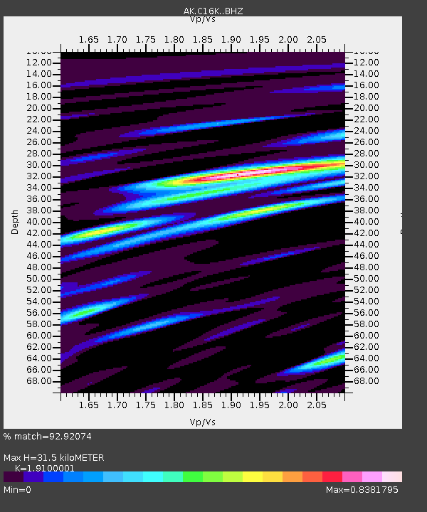
| Estimated Moho Depth: |
31.5 km |
| Estimated Crust Vp/Vs: |
1.91 |
| Assumed Crust Vp: |
5.906 km/s |
| Estimated Crust Vs: |
3.092 km/s |
| Estimated Crust Poisson's Ratio: |
0.31 |
|
| Radial Match: |
92.92074 % |
| Radial Bump: |
400 |
| Transverse Match: |
85.518654 % |
| Transverse Bump: |
400 |
| SOD ConfigId: |
26694651 |
| Insert Time: |
2021-11-24 15:46:40.938 +0000 |
| GWidth: |
2.5 |
| Max Bumps: |
400 |
| Tol: |
0.001 |
|

Signal To Noise
| Channel | StoN | STA | LTA |
| AK:C16K: :BHZ:20211110T15:54:50.520005Z | 8.207477 | 1.1400705E-6 | 1.3890634E-7 |
| AK:C16K: :BHN:20211110T15:54:50.520005Z | 2.0937238 | 2.433243E-7 | 1.1621606E-7 |
| AK:C16K: :BHE:20211110T15:54:50.520005Z | 4.578942 | 5.3608244E-7 | 1.17075615E-7 |
| Arrivals |
| Ps | 5.0 SECOND |
| PpPs | 15 SECOND |
| PsPs/PpSs | 20 SECOND |


