You are here: Home > Network List > AK - Alaska Regional Network Stations List
> Station CUT Chulitna, AK, USA > Earthquake Result Viewer
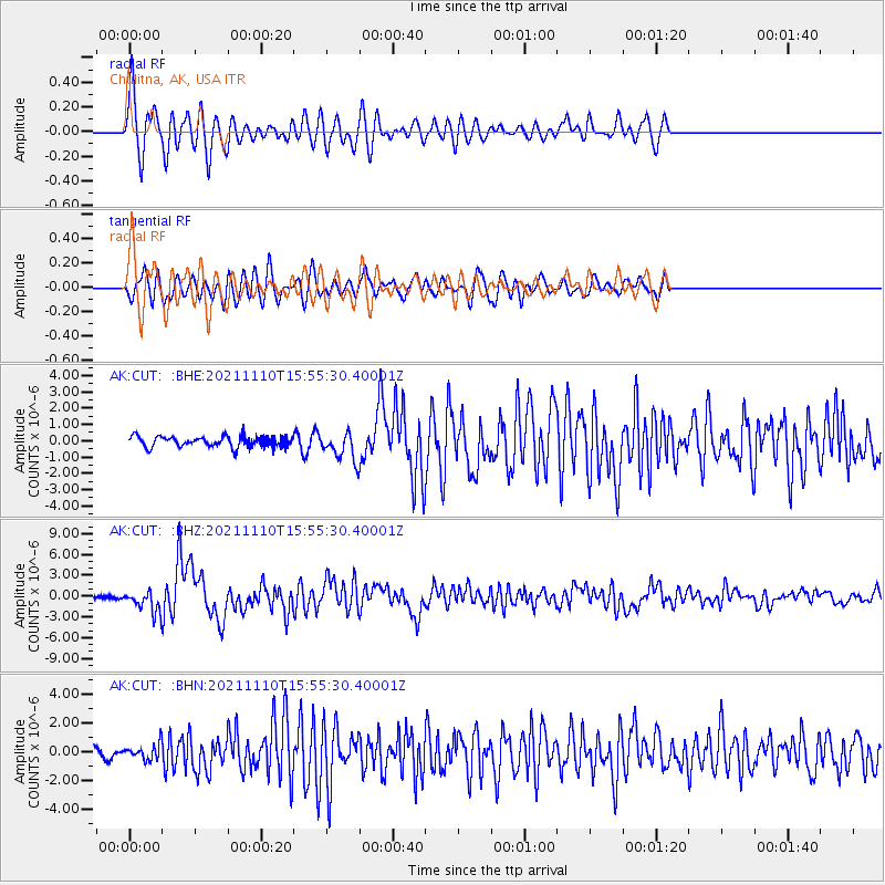
CUT Chulitna, AK, USA - Earthquake Result Viewer
*The percent match for this event was below the threshold and hence no stack was calculated.
| Earthquake location: |
Southeast Of Ryukyu Islands |
| Earthquake latitude/longitude: |
23.5/126.5 |
| Earthquake time(UTC): |
2021/11/10 (314) 15:45:13 GMT |
| Earthquake Depth: |
10 km |
| Earthquake Magnitude: |
6.6 Mww |
| Earthquake Catalog/Contributor: |
NEIC PDE/us |
|
| Network: |
AK Alaska Regional Network |
| Station: |
CUT Chulitna, AK, USA |
| Lat/Lon: |
62.41 N/150.26 W |
| Elevation: |
574 m |
|
| Distance: |
66.3 deg |
| Az: |
30.328 deg |
| Baz: |
275.614 deg |
| Ray Param: |
$rayparam |
*The percent match for this event was below the threshold and hence was not used in the summary stack. |
|
| Radial Match: |
79.73113 % |
| Radial Bump: |
400 |
| Transverse Match: |
67.97347 % |
| Transverse Bump: |
400 |
| SOD ConfigId: |
26694651 |
| Insert Time: |
2021-11-24 15:47:00.241 +0000 |
| GWidth: |
2.5 |
| Max Bumps: |
400 |
| Tol: |
0.001 |
|
Signal To Noise
| Channel | StoN | STA | LTA |
| AK:CUT: :BHZ:20211110T15:55:30.40001Z | 4.7545915 | 1.4707027E-6 | 3.0932264E-7 |
| AK:CUT: :BHN:20211110T15:55:30.40001Z | 1.1366513 | 4.959692E-7 | 4.363424E-7 |
| AK:CUT: :BHE:20211110T15:55:30.40001Z | 2.6340153 | 8.4864826E-7 | 3.2218807E-7 |
| Arrivals |
| Ps | |
| PpPs | |
| PsPs/PpSs | |


