You are here: Home > Network List > AU - Australian Seismological Centre Stations List
> Station PSAA1 Pilbara Seismic Array Element A1 > Earthquake Result Viewer
PSAA1 Pilbara Seismic Array Element A1 - Earthquake Result Viewer
| Earthquake location: |
Southeast Of Ryukyu Islands |
| Earthquake latitude/longitude: |
23.5/126.5 |
| Earthquake time(UTC): |
2021/11/10 (314) 15:45:13 GMT |
| Earthquake Depth: |
10 km |
| Earthquake Magnitude: |
6.6 Mww |
| Earthquake Catalog/Contributor: |
NEIC PDE/us |
|
| Network: |
AU Australian Seismological Centre |
| Station: |
PSAA1 Pilbara Seismic Array Element A1 |
| Lat/Lon: |
21.58 S/119.84 E |
| Elevation: |
325 m |
|
| Distance: |
45.3 deg |
| Az: |
188.712 deg |
| Baz: |
8.589 deg |
| Ray Param: |
0.071370035 |
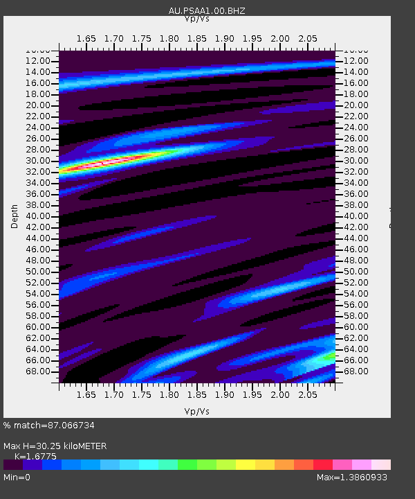
| Estimated Moho Depth: |
30.25 km |
| Estimated Crust Vp/Vs: |
1.68 |
| Assumed Crust Vp: |
6.464 km/s |
| Estimated Crust Vs: |
3.853 km/s |
| Estimated Crust Poisson's Ratio: |
0.22 |
|
| Radial Match: |
87.066734 % |
| Radial Bump: |
400 |
| Transverse Match: |
80.74344 % |
| Transverse Bump: |
400 |
| SOD ConfigId: |
26694651 |
| Insert Time: |
2021-11-24 15:51:04.405 +0000 |
| GWidth: |
2.5 |
| Max Bumps: |
400 |
| Tol: |
0.001 |
|

Signal To Noise
| Channel | StoN | STA | LTA |
| AU:PSAA1:00:BHZ:20211110T15:53:00.018998Z | 7.7025948 | 2.0228138E-6 | 2.6261458E-7 |
| AU:PSAA1:00:BH1:20211110T15:53:00.018998Z | 4.1540093 | 1.2849955E-6 | 3.0933862E-7 |
| AU:PSAA1:00:BH2:20211110T15:53:00.018998Z | 2.4363859 | 3.2320565E-7 | 1.3265783E-7 |
| Arrivals |
| Ps | 3.4 SECOND |
| PpPs | 12 SECOND |
| PsPs/PpSs | 15 SECOND |


