You are here: Home > Network List > AU - Australian Seismological Centre Stations List
> Station PSAB3 Pilbara Seismic Array Element B3 > Earthquake Result Viewer
PSAB3 Pilbara Seismic Array Element B3 - Earthquake Result Viewer
| Earthquake location: |
Southeast Of Ryukyu Islands |
| Earthquake latitude/longitude: |
23.5/126.5 |
| Earthquake time(UTC): |
2021/11/10 (314) 15:45:13 GMT |
| Earthquake Depth: |
10 km |
| Earthquake Magnitude: |
6.6 Mww |
| Earthquake Catalog/Contributor: |
NEIC PDE/us |
|
| Network: |
AU Australian Seismological Centre |
| Station: |
PSAB3 Pilbara Seismic Array Element B3 |
| Lat/Lon: |
21.59 S/119.85 E |
| Elevation: |
327 m |
|
| Distance: |
45.3 deg |
| Az: |
188.685 deg |
| Baz: |
8.563 deg |
| Ray Param: |
0.07136092 |
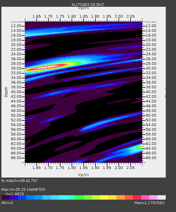
| Estimated Moho Depth: |
29.25 km |
| Estimated Crust Vp/Vs: |
1.69 |
| Assumed Crust Vp: |
6.464 km/s |
| Estimated Crust Vs: |
3.819 km/s |
| Estimated Crust Poisson's Ratio: |
0.23 |
|
| Radial Match: |
89.61757 % |
| Radial Bump: |
378 |
| Transverse Match: |
73.00707 % |
| Transverse Bump: |
400 |
| SOD ConfigId: |
26694651 |
| Insert Time: |
2021-11-24 15:51:12.579 +0000 |
| GWidth: |
2.5 |
| Max Bumps: |
400 |
| Tol: |
0.001 |
|

Signal To Noise
| Channel | StoN | STA | LTA |
| AU:PSAB3:00:BHZ:20211110T15:53:00.143998Z | 5.6384964 | 2.0478365E-6 | 3.631884E-7 |
| AU:PSAB3:00:BH1:20211110T15:53:00.143998Z | 0.89618564 | 1.5974571E-7 | 1.7825069E-7 |
| AU:PSAB3:00:BH2:20211110T15:53:00.143998Z | 6.2844615 | 1.0822739E-6 | 1.7221427E-7 |
| Arrivals |
| Ps | 3.4 SECOND |
| PpPs | 11 SECOND |
| PsPs/PpSs | 15 SECOND |


