You are here: Home > Network List > LI - Laser Interferometer Gravitational-Wave Experiment (LIGO) Stations List
> Station LTH LTH, Bishop, CA, USA > Earthquake Result Viewer
LTH LTH, Bishop, CA, USA - Earthquake Result Viewer
| Earthquake location: |
Vanuatu Islands |
| Earthquake latitude/longitude: |
-17.8/167.9 |
| Earthquake time(UTC): |
2009/06/02 (153) 02:17:03 GMT |
| Earthquake Depth: |
15 km |
| Earthquake Magnitude: |
5.7 MB, 6.2 MS, 6.3 MW, 6.3 MW |
| Earthquake Catalog/Contributor: |
WHDF/NEIC |
|
| Network: |
LI Laser Interferometer Gravitational-Wave Experiment (LIGO) |
| Station: |
LTH LTH, Bishop, CA, USA |
| Lat/Lon: |
46.46 N/119.42 W |
| Elevation: |
157 m |
|
| Distance: |
91.3 deg |
| Az: |
41.294 deg |
| Baz: |
245.469 deg |
| Ray Param: |
0.041612208 |
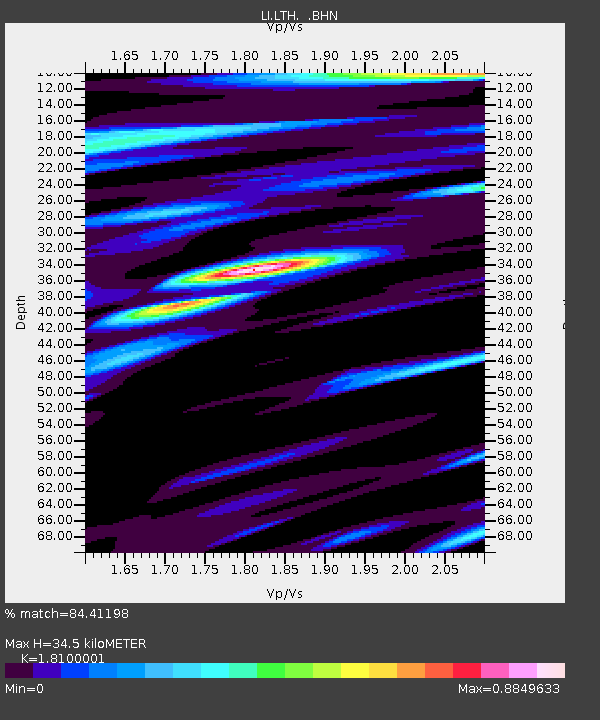
| Estimated Moho Depth: |
34.5 km |
| Estimated Crust Vp/Vs: |
1.81 |
| Assumed Crust Vp: |
6.419 km/s |
| Estimated Crust Vs: |
3.547 km/s |
| Estimated Crust Poisson's Ratio: |
0.28 |
|
| Radial Match: |
84.41198 % |
| Radial Bump: |
400 |
| Transverse Match: |
65.62442 % |
| Transverse Bump: |
400 |
| SOD ConfigId: |
2648 |
| Insert Time: |
2010-03-09 14:04:16.190 +0000 |
| GWidth: |
2.5 |
| Max Bumps: |
400 |
| Tol: |
0.001 |
|

Signal To Noise
| Channel | StoN | STA | LTA |
| LI:LTH: :BHN:20090602T02:29:36.635Z | 4.9763966 | 4.4639296E-7 | 8.970204E-8 |
| LI:LTH: :BHE:20090602T02:29:36.635Z | 0.957289 | 1.6943548E-7 | 1.7699513E-7 |
| LI:LTH: :BHZ:20090602T02:29:36.635Z | 1.3183787 | 1.3662623E-7 | 1.03632E-7 |
| Arrivals |
| Ps | 4.4 SECOND |
| PpPs | 15 SECOND |
| PsPs/PpSs | 19 SECOND |


